IMAGES TAKEN NEAR TO
DUNFERMLINE, KY99 4AA
Introduction
This page details the photographs taken nearby to KY99 4AA by members of the Geograph project.
The Geograph project started in 2005 with the aim of publishing, organising and preserving representative images for every square kilometre of Great Britain, Ireland and the Isle of Man.

There are currently over 7.5m images from over14,400 individuals and you can help contribute to the project by visiting https://www.geograph.org.uk
Image Map
Images are licensed for reuse under creativecommons.org/licenses/by-sa/2.0
Notes
- Clicking on the map will re-center to the selected point.
- The higher the marker number, the further away the image location is from the centre of the postcode.
Image Listing (141 Images Found)
Images are licensed for reuse under creativecommons.org/licenses/by-sa/2.0
Image
Details
Distance
1
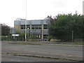
Bank of Scotland Offices
On Bothwell Street, Dunfermline.
Image: © M J Richardson
Taken: 24 Sep 2019
0.00 miles
4
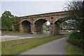
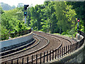
Railway Viaduct
This viaduct carries the rail line from Inverkeithing junction to Dunfermline and all points east.
Image: © Robert Struthers
Taken: 29 Apr 2011
0.03 miles
5
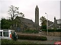
St Leonard's Church
Built more than a hundred years ago this church still plays a part in the lives of local people
Image: © Paul McIlroy
Taken: 22 Sep 2005
0.04 miles
6
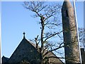
Tree Surgeon.
At work on a tree in the grounds of St Leonard's Church.
Image: © Paul McIlroy
Taken: 9 Nov 2005
0.04 miles
7
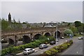
Railway Viaduct
Sharp reflexes and nerves of steel required to negotiate the roundabout that weaves between the arches of the viaduct.
Image: © Robert Struthers
Taken: 29 Apr 2011
0.04 miles
8
Bothwell Street railway viaduct
The desck of part of the 13 span Category B Listed http://portal.historicenvironment.scot/designation/LB46881 viaduct which was built by the North British Railway Co in 1874-77. The A823 St Margaret's Drive is in the foreground. Viewed from the footbridge which leads to Dunfermline Town railway station.
Image: © Thomas Nugent
Taken: 4 Jun 2016
0.04 miles
9
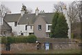
House
This house, which is called The Rhodes, is situated between Rhodes Street and Bothwell Street and it is reputed to be the oldest inhabited house in Dunfermline. It was built in 1695 in the Scottish Vernacular Style and is a Category B listed building.
Image: © Paul McIlroy
Taken: 11 Mar 2007
0.05 miles
10
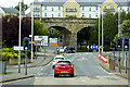
Bothwell Street Railway Viaduct, Dunfermline
Part of a 13-span sandstone viaduct built in the 1870s for the North British Railway. It is a Category B listed building (LB46881 http://portal.historicenvironment.scot/designation/LB46881 Historic Scotland).
Image: © David Dixon
Taken: 23 May 2017
0.05 miles