IMAGES TAKEN NEAR TO
Baird Place, LEVEN, KY9 1EH
Introduction
This page details the photographs taken nearby to Baird Place, KY9 1EH by members of the Geograph project.
The Geograph project started in 2005 with the aim of publishing, organising and preserving representative images for every square kilometre of Great Britain, Ireland and the Isle of Man.

There are currently over 7.5m images from over14,400 individuals and you can help contribute to the project by visiting https://www.geograph.org.uk
Image Map
Images are licensed for reuse under creativecommons.org/licenses/by-sa/2.0
Notes
- Clicking on the map will re-center to the selected point.
- The higher the marker number, the further away the image location is from the centre of the postcode.
Image Listing (145 Images Found)
Images are licensed for reuse under creativecommons.org/licenses/by-sa/2.0
Image
Details
Distance
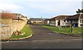
1
Baird Place, Elie
This cul-de-sac was once the site of Elie Railway Station.
See Elie and Earlsferry article https://www.geograph.org.uk/article/Elie-and-Earlsferry
Image: © Bill Kasman
Taken: 3 Feb 2020
0.01 miles
2
Baird Place, Elie
This cul-de-sac was once the site of Elie Railway Station which was located roughly where the houses are.
See Elie and Earlsferry article https://www.geograph.org.uk/article/Elie-and-Earlsferry
Image: © Bill Kasman
Taken: 3 Feb 2020
0.01 miles
3
Elie: eastward on A917 road past site of former station, 2002
View eastward, towards Anstruher, Crail and St Andrews: ex-NBR Thornton Junction - Crail- St Andrews line. The station was closed 6/9/65 along with the line Leven - Crail, Crail - St Andrews having closed 5/10/64 and Thornton Junction - Leven 6/10/69. On the left is the park of Elie House.
Image: © Ben Brooksbank
Taken: 30 Jun 2002
0.03 miles
4
Road to Wadeslea Cottages
This private road runs beside Elie Surgery and gives access to several properties.
See Elie and Earlsferry article https://www.geograph.org.uk/article/Elie-and-Earlsferry
Image: © Bill Kasman
Taken: 29 Dec 2019
0.04 miles
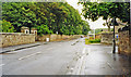
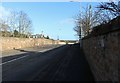
5
The A917 enters Elie
From the St Monans direction.
See Elie and Earlsferry article https://www.geograph.org.uk/article/Elie-and-Earlsferry
Image: © Bill Kasman
Taken: 3 Feb 2020
0.05 miles
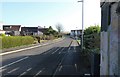
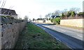
6
The A917 leaves Elie
Heading east towards St Monans. The sight rise in the road here was a bridge over the former Leven and East of Fife Railway (closed in 1965) the trackbed of which can still be seen over the wall to the left https://en.wikipedia.org/wiki/Fife_Coast_Railway#The_Leven_and_East_of_Fife_Railway
See Elie and Earlsferry article https://www.geograph.org.uk/article/Elie-and-Earlsferry
Image: © Bill Kasman
Taken: 3 Feb 2020
0.06 miles
7
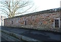
Reinforced bridge parapet
These three reinforcing plates are located on the bridge on the A917 as it leaves Elie heading east Image The bridge spans the former railway line.
See Elie and Earlsferry article https://www.geograph.org.uk/article/Elie-and-Earlsferry
Image: © Bill Kasman
Taken: 3 Feb 2020
0.06 miles
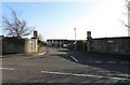
8
Road behind Wadeslea Cottages
This private road is a cul-de-sac which begins at the junction of Wadeslea and the A917 High Street and runs behind Wadeslea Cottages Image
See Elie and Earlsferry article https://www.geograph.org.uk/article/Elie-and-Earlsferry
Image: © Bill Kasman
Taken: 29 Dec 2019
0.06 miles
9
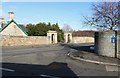
Entrance to Elie Estate
These gates, off the A917 as it leaves Elie heading for St Monans, mark the entrance to Elie Estate where the Category A Listed Building of Elie House (which dates from 1697) can be found. Elie Estate is now owned by the Elie Estate Trust under the stewardship of the Nairn family. Elie House was once a convent but now serves as domestic residences.
See Elie and Earlsferry article https://www.geograph.org.uk/article/Elie-and-Earlsferry
Image: © Bill Kasman
Taken: 3 Feb 2020
0.06 miles
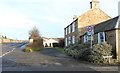
10

Elie Surgery
Located in Wadeslea this facility provides GP and other health-related services to the community.
See Elie and Earlsferry article https://www.geograph.org.uk/article/Elie-and-Earlsferry
Image: © Bill Kasman
Taken: 29 Dec 2019
0.06 miles