IMAGES TAKEN NEAR TO
Lodge Walk, LEVEN, KY9 1EE
Introduction
This page details the photographs taken nearby to Lodge Walk, KY9 1EE by members of the Geograph project.
The Geograph project started in 2005 with the aim of publishing, organising and preserving representative images for every square kilometre of Great Britain, Ireland and the Isle of Man.

There are currently over 7.5m images from over14,400 individuals and you can help contribute to the project by visiting https://www.geograph.org.uk
Image Map
Images are licensed for reuse under creativecommons.org/licenses/by-sa/2.0
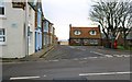
Notes
- Clicking on the map will re-center to the selected point.
- The higher the marker number, the further away the image location is from the centre of the postcode.
Image Listing (346 Images Found)
Images are licensed for reuse under creativecommons.org/licenses/by-sa/2.0
Image
Details
Distance
1
Stenton Row, Elie
After about 200m Stenton Row becomes The Toft and heads down to the harbour. Toll Green is on the right.
See Elie and Earlsferry article https://www.geograph.org.uk/article/Elie-and-Earlsferry
Image: © Bill Kasman
Taken: 14 Dec 2019
0.02 miles
2
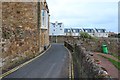
The Terrace, Elie
The Terrace approaches its junction with The Toft. This section of The Terrace has great views over Elie Harbour.
See Elie and Earlsferry article https://www.geograph.org.uk/article/Elie-and-Earlsferry
Image: © Bill Kasman
Taken: 14 Dec 2019
0.02 miles
3
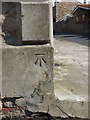
OS benchmark - Elie, 1, The Terrace
OS cutmark in the stone corner pillar of No 1, The Terrace. Originally levelled at 8.94m above Ordnance Datum Newlyn.
Image: © Richard Law
Taken: 3 Jul 2013
0.02 miles
5
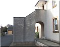
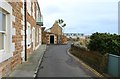
Lodge Walk, Elie
A curious solution to access an upstairs flat!
See Elie and Earlsferry article https://www.geograph.org.uk/article/Elie-and-Earlsferry
Image: © Bill Kasman
Taken: 29 Dec 2019
0.03 miles
6
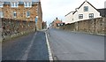
The Toft, Elie
The Toft becomes Stenton Row after its junction with The Terrace (on the left) and continues to join High Street (A917)
See Elie and Earlsferry article https://www.geograph.org.uk/article/Elie-and-Earlsferry
Image: © Bill Kasman
Taken: 14 Dec 2019
0.03 miles
7
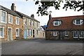
Stenton Row, Elie
Stenton House (centre) is an early 19th century Georgian property on Stenton Row, which is Category C listed https://portal.historicenvironment.scot/apex/f?p=1505:300:::::VIEWTYPE,VIEWREF:designation,LB31035. On the right the cottages on High Street Lane date from around 1800 and are also Category C listed https://portal.historicenvironment.scot/apex/f?p=1505:300:::::VIEWTYPE,VIEWREF:designation,LB30968.
Image: © Richard Sutcliffe
Taken: 26 Sep 2024
0.03 miles
8
Lodge Walk, Elie
A cul-de-sac of private homes.
See Elie and Earlsferry article https://www.geograph.org.uk/article/Elie-and-Earlsferry
Image: © Bill Kasman
Taken: 29 Dec 2019
0.03 miles
9
The Terrace, Elie
This section of The Terrace has a great view over Elie Harbour.
See Elie and Earlsferry article https://www.geograph.org.uk/article/Elie-and-Earlsferry
Image: © Bill Kasman
Taken: 14 Dec 2019
0.03 miles
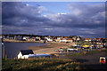
10
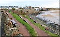
The Terrace, Elie
This public seating area has a wonderful view over Elie Harbour. This area can get very busy on a warm and sunny day when activities are taking place in the harbour.
See Elie and Earlsferry article https://www.geograph.org.uk/article/Elie-and-Earlsferry
Image: © Bill Kasman
Taken: 14 Dec 2019
0.04 miles