IMAGES TAKEN NEAR TO
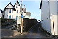
Admiralty Square, LEVEN, KY9 1BN
Introduction
This page details the photographs taken nearby to Admiralty Square, KY9 1BN by members of the Geograph project.
The Geograph project started in 2005 with the aim of publishing, organising and preserving representative images for every square kilometre of Great Britain, Ireland and the Isle of Man.

There are currently over 7.5m images from over14,400 individuals and you can help contribute to the project by visiting https://www.geograph.org.uk
Image Map
Images are licensed for reuse under creativecommons.org/licenses/by-sa/2.0
Notes
- Clicking on the map will re-center to the selected point.
- The higher the marker number, the further away the image location is from the centre of the postcode.
Image Listing (338 Images Found)
Images are licensed for reuse under creativecommons.org/licenses/by-sa/2.0
Image
Details
Distance
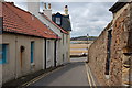
1
Admiralty Lane, Elie
Elie Shipyard was somewhere in this area but its precise location is uncertain http://www.eliehistory.com/explore/elie-shipyard/
See Elie and Earlsferry article https://www.geograph.org.uk/article/Elie-and-Earlsferry
Image: © Bill Kasman
Taken: 18 Dec 2019
0.00 miles
2
Admiralty Lane, Elie
As it leaves The Toft, heading east.
See Elie and Earlsferry article https://www.geograph.org.uk/article/Elie-and-Earlsferry
Image: © Bill Kasman
Taken: 29 Dec 2019
0.00 miles
3
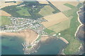
Aerial Photo of Elie
Photo taken from a Cessna 152 "G-TAYS" at altitude 2500' on the 20th August 2007 during a navigation exercise. The East end of the town is clearly visible and the popular beer garden in front of the harbour pub is visible...
Image: © alistair cameron
Taken: 20 Aug 2007
0.01 miles
4
The Toft, Elie
The white building on the right of the image is The Ship Inn. The white building on the left is the Beachfront Bar and an open-air seating area which belongs to The Ship Inn.
See Elie and Earlsferry article https://www.geograph.org.uk/article/Elie-and-Earlsferry
Image: © Bill Kasman
Taken: 18 Dec 2019
0.02 miles
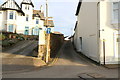
6

Notice Board, The Toft, Elie
See Elie and Earlsferry article https://www.geograph.org.uk/article/Elie-and-Earlsferry
Image: © Bill Kasman
Taken: 18 Dec 2019
0.02 miles
7
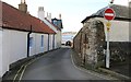
Admiralty Lane, Elie
Looking towards Elie Harbour.
See Elie and Earlsferry article https://www.geograph.org.uk/article/Elie-and-Earlsferry
Image: © Bill Kasman
Taken: 29 Dec 2019
0.02 miles
8
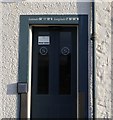
Location of The Ship Inn, Elie
Just in case customers forget where it is The Ship Inn displays its latitude and longitude above the door!
See Elie and Earlsferry article https://www.geograph.org.uk/article/Elie-and-Earlsferry
Image: © Bill Kasman
Taken: 18 Dec 2019
0.02 miles
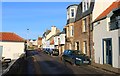
9
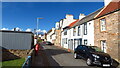
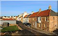
A lane in Elie
Elie is one of several attractive coastal villages in Fife, with the red tiled cottages that are common around the Firth of Forth.
Image: © Jim Barton
Taken: 22 Jun 2011
0.03 miles
10
The Toft, Elie
See Elie and Earlsferry article https://www.geograph.org.uk/article/Elie-and-Earlsferry
Image: © Bill Kasman
Taken: 18 Dec 2019
0.03 miles