IMAGES TAKEN NEAR TO
Cavell Place, LEVEN, KY9 1AT
Introduction
This page details the photographs taken nearby to Cavell Place, KY9 1AT by members of the Geograph project.
The Geograph project started in 2005 with the aim of publishing, organising and preserving representative images for every square kilometre of Great Britain, Ireland and the Isle of Man.

There are currently over 7.5m images from over14,400 individuals and you can help contribute to the project by visiting https://www.geograph.org.uk
Image Map
Images are licensed for reuse under creativecommons.org/licenses/by-sa/2.0
Notes
- Clicking on the map will re-center to the selected point.
- The higher the marker number, the further away the image location is from the centre of the postcode.
Image Listing (137 Images Found)
Images are licensed for reuse under creativecommons.org/licenses/by-sa/2.0
Image
Details
Distance
1
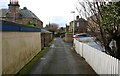
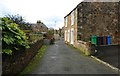
Rotten Row, Earlsferry
This quiet and narrow road was once part of Earlsferry's High Street until Williamsburgh was redeveloped and became the new thoroughfare through the village.
See Elie and Earlsferry article https://www.geograph.org.uk/article/Elie-and-Earlsferry
Image: © Bill Kasman
Taken: 13 Dec 2019
0.02 miles
2
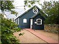
St Michael and All Angels Church, Earlsferry
Tucked away in the quiet street of Rotten Row is this Scottish Episcopal Church. The building has an interesting history having originally been built in the grounds of Craigforth, a house near Chapel Green but, upon the death of the houseowner in 1932, was moved in its entirety to its present location.
See Elie and Earlsferry article https://www.geograph.org.uk/article/Elie-and-Earlsferry
Image: © Bill Kasman
Taken: 13 Dec 2019
0.02 miles
3
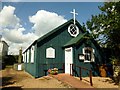
St Michael's Episcopal Church, Earlsferry
St Michael's Church is built of wood clad with a corrugated material. Although it is over 100 years old, the building is in good repair. Everyone who enters is surprised at its pleasant peaceful atmosphere. The church will seat 100.
Image: © Rude Health
Taken: 7 Aug 2014
0.02 miles
4

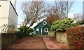
Sign at church
Tucked away in the quiet street of Rotten Row Image is this Scottish Episcopal Church.
See Elie and Earlsferry article https://www.geograph.org.uk/article/Elie-and-Earlsferry
Image: © Bill Kasman
Taken: 13 Dec 2019
0.02 miles
5
Rotten Row, Earlsferry
Off Williamsburgh this is one end of the crescent road of Rotten Row.
See Elie and Earlsferry article https://www.geograph.org.uk/article/Elie-and-Earlsferry
Image: © Bill Kasman
Taken: 6 Dec 2019
0.02 miles
6
Rotten Row, Earlsferry
This quiet and narrow road was once part of Earlsferry's High Street until Williamsburgh was redeveloped and became the new thoroughfare through the village.
See Elie and Earlsferry article https://www.geograph.org.uk/article/Elie-and-Earlsferry
Image: © Bill Kasman
Taken: 13 Dec 2019
0.02 miles
7
St Michael's Episcopal Church, Earlsferry
This stands just off the delightfully-named Rotten Row, behind the main street through Earlsferry.
Image: © Richard Law
Taken: 25 May 2009
0.03 miles
8
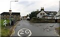
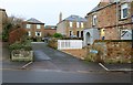
Ferry Road, Earlsferry
After leaving the A917 at Broomlees Farm Ferry Road enters Earlsferry. Earlsferry Links Golf Course is cut in half by Ferry Road and golfers must cross from one side to the other by the white barriers on the left. The turning to the right is Links Road.
See Elie and Earlsferry article https://www.geograph.org.uk/article/Elie-and-Earlsferry
Image: © Bill Kasman
Taken: 6 Dec 2019
0.03 miles
9
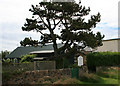
St Michael and All Angels
Scottish Episcopal Church, East Neuk of Fife, Elie.
Image: © Geoff Gartside
Taken: 7 Jul 2007
0.03 miles
10
Ferry Road, Elie and Earlsferry
Ferry Road runs through Earlsferry from the beach (behind the camera) to the A917 at Broomlees Farm. High Street is to the left and Williamsburgh (road) is to the right.
See Elie and Earlsferry article https://www.geograph.org.uk/article/Elie-and-Earlsferry
Image: © Bill Kasman
Taken: 6 Dec 2019
0.03 miles