IMAGES TAKEN NEAR TO
High Street, LEVEN, KY9 1AF
Introduction
This page details the photographs taken nearby to High Street, KY9 1AF by members of the Geograph project.
The Geograph project started in 2005 with the aim of publishing, organising and preserving representative images for every square kilometre of Great Britain, Ireland and the Isle of Man.

There are currently over 7.5m images from over14,400 individuals and you can help contribute to the project by visiting https://www.geograph.org.uk
Image Map
Images are licensed for reuse under creativecommons.org/licenses/by-sa/2.0
Notes
- Clicking on the map will re-center to the selected point.
- The higher the marker number, the further away the image location is from the centre of the postcode.
Image Listing (129 Images Found)
Images are licensed for reuse under creativecommons.org/licenses/by-sa/2.0
Image
Details
Distance
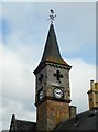
1
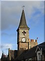
The Town Clock, High Street
The clock tower of the Town Hall in Earlsferry.
Image: © kim traynor
Taken: 7 Nov 2013
0.01 miles
2
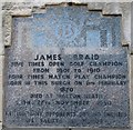
Plaque on Earlsferry Town Hall
This plaque is next to the door of the Town Hall.
See Elie and Earlsferry article https://www.geograph.org.uk/article/Elie-and-Earlsferry
Image: © Bill Kasman
Taken: 12 Dec 2019
0.02 miles
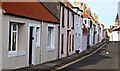
3
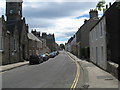
Street scene in Earlsferry
The principal street in the old Royal Burgh. Earlsferry was once an important ferry port to North Berwick across the Firth of Forth and is also the route the Earl of Fife took when escaping from persecution and almost certain death at the hands of Macbeth.
Image: © James Denham
Taken: 22 Jun 2009
0.02 miles
4
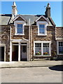
'The Pend House', 29 High Street, Earlsferry
Category C listed https://www.britishlistedbuildings.co.uk/200372250-earlsferry-29-high-street-east-neuk-and-landward-ward#.W2SBQ9QrLGg in 1972 along with many of the neighbouring properties, The Pend House is late Victorian in age. It gains its listed status for 'group value' rather than for any specific features.
Image: © Richard Law
Taken: 14 May 2018
0.02 miles
5
Former town hall tower, Anstruther
The former town hall is a Category B listed building [http://portal.historicenvironment.scot/designation/LB31056] dating from 1872.
Image: © Richard Sutcliffe
Taken: 20 Mar 2019
0.02 miles
6
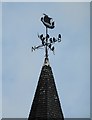
Weather vane, former town hall, Earlsferry
It makes a good perch for the local starlings.
Image: © Richard Sutcliffe
Taken: 20 Mar 2019
0.02 miles
7
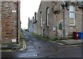
Cross Wynd, Earlsferry
The building to the right is Earlsferry Town Hall which now functions as a village hall.
See Elie and Earlsferry article https://www.geograph.org.uk/article/Elie-and-Earlsferry
Image: © Bill Kasman
Taken: 6 Dec 2019
0.02 miles
8
Earlsferry High Street
View down Earlsferry High Street in the East Neuk of Fife.
Image: © Jerzy Morkis
Taken: 27 Sep 2020
0.02 miles
9
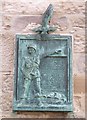
Polish Paratroops plaque, Earlsferry Town Hall
Although this subject has been photographed by others, I've posted this image in order to provide an explanation.
During the Second World War Polish forces fought on in exile after the defeat of Poland in 1939, first in France and then as part of the Allied war effort in the West. With the eventual release of Polish troops from Soviet captivity, following the German invasion of the Soviet Union in 1941, the Poles came to form the fourth largest contingent among the Allied forces after the U.S.S.R., U.S.A. and Great Britain.
At the time of the Fall of France in 1940 some 17,000 Polish troops were among those evacuated from Dunkirk and the ports of western France (this number grew to 26,500 by mid-1944). Directed to Scotland by the War Office, they were initially stationed in Lanarkshire and Peeblesshire but soon moved to more permanent bases in Fife, Angus and Perthshire. Regrouped as the 1st Polish Corps under their Commander-in-Chief General Sikorski, in October 1940 they were given the task of building up the defences of the coasts of Fife, Angus and latterly East Lothian from a possible invasion from German-occupied Norway. In 1941 the Corps was reorganised and gradually re-equipped for combat. One of the new units was the 1st (Polish) Independent Parachute Brigade under the command of Colonel, later Major-General Stanisław Sosabowski. The Brigade was based at Upper Largo, about 5 miles from Earlsferry, where an assault course and jump tower were constructed for training in the grounds of Largo House. Their intended mission was to land in Poland to join the underground Polish Home Army in the fight to liberate their country from Nazi occupation. However, in the summer of 1944 the Brigade, now numbering about 3,100 men, was moved to England and sent into action in September of that year in support of the British 1st Airborne Division at the battle of Arnhem. They suffered heavy losses in what has come to be widely regarded as a partly bungled British military operation.
The plaque expresses the Brigade's gratitude for the hospitality shown them by the people of Elie and Earlsferry during their time in Fife from 1940 to 1943.
For more on the Brigade's war record, see https://en.wikipedia.org/wiki/Polish_Parachute_Brigade and https://en.wikipedia.org/wiki/Stanis%C5%82aw_Sosabowski
Image: © kim traynor
Taken: 7 Nov 2013
0.02 miles
10

Earlsferry Town Hall
Built in 1872 the building is no longer used for official business and now functions as a village hall and was also previously used as a cinema. The base of the clock tower (built 1772) was the old town council meeting room and the town jail. There are two interesting plaques affixed to the building.
See Elie and Earlsferry article https://www.geograph.org.uk/article/Elie-and-Earlsferry
Image: © Bill Kasman
Taken: 6 Dec 2019
0.02 miles