IMAGES TAKEN NEAR TO
Bourtree Brae, LEVEN, KY8 6HX
Introduction
This page details the photographs taken nearby to Bourtree Brae, KY8 6HX by members of the Geograph project.
The Geograph project started in 2005 with the aim of publishing, organising and preserving representative images for every square kilometre of Great Britain, Ireland and the Isle of Man.

There are currently over 7.5m images from over14,400 individuals and you can help contribute to the project by visiting https://www.geograph.org.uk
Image Map
Images are licensed for reuse under creativecommons.org/licenses/by-sa/2.0
Notes
- Clicking on the map will re-center to the selected point.
- The higher the marker number, the further away the image location is from the centre of the postcode.
Image Listing (253 Images Found)
Images are licensed for reuse under creativecommons.org/licenses/by-sa/2.0
Image
Details
Distance
1
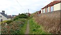
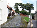
A tight squeeze!
This is the route of the former Fife Coast Railway (now part of the Fife Coastal Path) through Lower Largo. This section is particularly narrow!
See Lower Largo article https://www.geograph.org.uk/article/Lower-Largo-and-the-Serpentine-Walk
Image: © Bill Kasman
Taken: 29 Mar 2019
0.03 miles
2
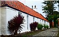
Pantiles and palms
A red pantile-roofed cottage in Lower Largo with palm trees growing in front.
Image: © James Allan
Taken: 11 Jun 2012
0.03 miles
3
123 Main Street, Lower Largo
Once known as East End Cottages, at which time it was 3 19th century cottages (but now converted to a single property) and Category C listed https://www.britishlistedbuildings.co.uk/200341142-lower-largo-123-main-street-formerly-east-end-cottages-leven-kennoway-and-largo-ward#.W2XYJtQrLGg by Historic Scotland in 1984.
Image: © Richard Law
Taken: 15 May 2018
0.03 miles
4
123 Main Street, Lower Largo
Originally three 19th century cottages, known as East End Cottages, now converted into a single house. Category C listed.
Image: © Richard Sutcliffe
Taken: 23 Mar 2019
0.03 miles
5
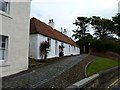
Entrance to Cardy House from Main Street
Image: © Andrew Curtis
Taken: 20 Aug 2019
0.03 miles
6
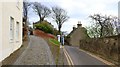
Main Street, Lower Largo
Main Street takes a sharp right turn ahead. The house at the turn is Cardy Cottage and immediately to its left is a footpath which leads to Temple car park. The two white pillars mark the pedestrian entrance to Cardy House which is also served by the stone sett roadway on the left. This roadway also leads to a path which connects to the Fife Coastal Path above Cardy House Image
See Lower Largo article https://www.geograph.org.uk/article/Lower-Largo-and-the-Serpentine-Walk
Image: © Bill Kasman
Taken: 29 Mar 2019
0.03 miles
7
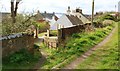
Fife Coastal Path
The Fife Coastal Path is visible to the right. The path heading downhill passes Cardy House (to the left but not visible) and joins Main Street Image
See Lower Largo article https://www.geograph.org.uk/article/Lower-Largo-and-the-Serpentine-Walk
Image: © Bill Kasman
Taken: 30 Mar 2019
0.03 miles
8
121 Main Street, Lower Largo
Effectively the eastern end of the same building seen in Image, but separately Category B listed https://www.britishlistedbuildings.co.uk/200341141-lower-largo-119-and-west-part-121-main-street-leven-kennoway-and-largo-ward#.W2XXsNQrLGg in 1984.
Image: © Richard Law
Taken: 15 May 2018
0.03 miles
9
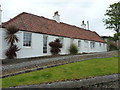
Lower Largo cottage, Fife
Cottages on Main Street, by Cardy House, Lower Largo, Fife.
Image: © Jerzy Morkis
Taken: 7 Oct 2021
0.03 miles
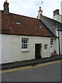
10
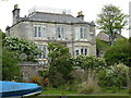
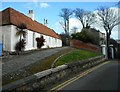
Cardy House, 125 Main Street, Lower Largo
Built in 1873 for David Gillies, the proprietor and owner of the nearby net works factory Image, and Category B listed https://www.britishlistedbuildings.co.uk/200341143-lower-largo-main-street-cardy-house-leven-kennoway-and-largo-ward#.W2XcXNQrLGg just over 100 years later in 1984.
Image: © Richard Law
Taken: 15 May 2018
0.03 miles