IMAGES TAKEN NEAR TO
Dumbarnie Place, LEVEN, KY8 6EY
Introduction
This page details the photographs taken nearby to Dumbarnie Place, KY8 6EY by members of the Geograph project.
The Geograph project started in 2005 with the aim of publishing, organising and preserving representative images for every square kilometre of Great Britain, Ireland and the Isle of Man.

There are currently over 7.5m images from over14,400 individuals and you can help contribute to the project by visiting https://www.geograph.org.uk
Image Map
Images are licensed for reuse under creativecommons.org/licenses/by-sa/2.0
Notes
- Clicking on the map will re-center to the selected point.
- The higher the marker number, the further away the image location is from the centre of the postcode.
Image Listing (135 Images Found)
Images are licensed for reuse under creativecommons.org/licenses/by-sa/2.0
Image
Details
Distance
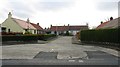
1
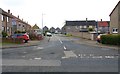
Aithernie Drive, Upper Largo
See Upper Largo article https://www.geograph.org.uk/article/Upper-Largo
Image: © Bill Kasman
Taken: 18 Apr 2019
0.01 miles
2
Dumbarnie Place, Upper Largo
Dumbarnie Place is a cul-de-sac off Aithernie Drive.
See Upper Largo article https://www.geograph.org.uk/article/Upper-Largo
Image: © Bill Kasman
Taken: 18 Apr 2019
0.01 miles
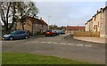
3
Aithernie Drive, Upper Largo
This turning to the right off Woodlands Park (the A915 road to St Andrews) is Aithernie Drive which continues on to join Main Street (A917) just before it leaves the village.
See Upper Largo article https://www.geograph.org.uk/article/Upper-Largo
Image: © Bill Kasman
Taken: 18 Apr 2019
0.03 miles
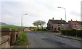
4
Aithernie Drive, Upper Largo
Looking towards the A915 road to St Andrews. Dumbarnie Place is on the left.
See Upper Largo article https://www.geograph.org.uk/article/Upper-Largo
Image: © Bill Kasman
Taken: 18 Apr 2019
0.03 miles
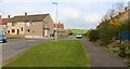
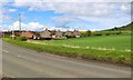
5
Woodlaw Park, Upper Largo
Off the A915 road to St Andrews
See Upper Largo article https://www.geograph.org.uk/article/Upper-Largo
Image: © Bill Kasman
Taken: 18 Apr 2019
0.06 miles
6
Aithernie Drive, Upper Largo
The rear of houses in Aithernie Drive.
See Upper Largo article https://www.geograph.org.uk/article/Upper-Largo
Image: © Bill Kasman
Taken: 26 Apr 2019
0.06 miles
7
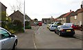
Aithernie Drive, Upper Largo
Looking towards its junction with the A917 Main Street just as it leaves the village.
See Upper Largo article https://www.geograph.org.uk/article/Upper-Largo
Image: © Bill Kasman
Taken: 18 Apr 2019
0.06 miles
8
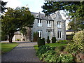
'Lyndhurst' on St Andrews Road, Upper Largo
Built around 1850, and Category B listed https://britishlistedbuildings.co.uk/200341242-upper-largo-st-andrews-road-lyndhurst-leven-kennoway-and-largo-ward#.W-sgudSLTGg in 1984. At one time shortly after its building, it was used as a church manse for the village.
Image: © Richard Law
Taken: 30 Sep 2018
0.07 miles
9
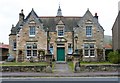
Simpson Institute, Upper Largo
Opened on 8th May 1891 the Institute was donated to the village by Mrs Janet Simpson in memory of her father, George Simpson. It functions as a village hall.
See Upper Largo article https://www.geograph.org.uk/article/Upper-Largo
Image: © Bill Kasman
Taken: 17 Apr 2019
0.07 miles
10
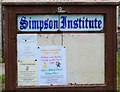
Notice Board, Upper Largo
This notice board was in the garden of the Simpson Institute in Main Street.
See Upper Largo article https://www.geograph.org.uk/article/Upper-Largo
Image: © Bill Kasman
Taken: 17 Apr 2019
0.07 miles