IMAGES TAKEN NEAR TO
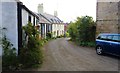
Broomfield Gardens, LEVEN, KY8 6EP
Introduction
This page details the photographs taken nearby to Broomfield Gardens, KY8 6EP by members of the Geograph project.
The Geograph project started in 2005 with the aim of publishing, organising and preserving representative images for every square kilometre of Great Britain, Ireland and the Isle of Man.

There are currently over 7.5m images from over14,400 individuals and you can help contribute to the project by visiting https://www.geograph.org.uk
Image Map
Images are licensed for reuse under creativecommons.org/licenses/by-sa/2.0
Notes
- Clicking on the map will re-center to the selected point.
- The higher the marker number, the further away the image location is from the centre of the postcode.
Image Listing (171 Images Found)
Images are licensed for reuse under creativecommons.org/licenses/by-sa/2.0
Image
Details
Distance
1
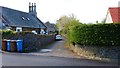
Church Place, Upper Largo
Church Place from North Feus. Largo Parish Church can be seen.
See Upper Largo article https://www.geograph.org.uk/article/Upper-Largo
Image: © Bill Kasman
Taken: 26 Apr 2019
0.01 miles
2
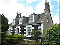
Rose Cottage, 3 North Feus, Upper Largo
Built around 1860, and Category B listed https://britishlistedbuildings.co.uk/200341240-upper-largo-3-north-feus-rose-cottage-leven-kennoway-and-largo-ward#.W-iMKtSLTGg in 1984, Rose Cottage displays a fine set of 3 bowed attic dormers which are typical of the area; there are several further examples of these in houses on South Feus.
Image: © Richard Law
Taken: 30 Sep 2018
0.01 miles
3
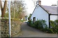
Church Place, Upper Largo
This offshoot of Church Place joins North Feus after about 300 metres.
See Upper Largo article https://www.geograph.org.uk/article/Upper-Largo
Image: © Bill Kasman
Taken: 18 Apr 2019
0.02 miles
4

North Feus, Upper Largo
See Upper Largo article https://www.geograph.org.uk/article/Upper-Largo
Image: © Bill Kasman
Taken: 26 Apr 2019
0.02 miles
5
Church Place, Upper Largo
Largo and Newburn Parish Church is on the right.
See Upper Largo article https://www.geograph.org.uk/article/Upper-Largo
Image: © Bill Kasman
Taken: 18 Apr 2019
0.02 miles
6
Church Place, Upper Largo
See Upper Largo article https://www.geograph.org.uk/article/Upper-Largo
Image: © Bill Kasman
Taken: 18 Apr 2019
0.02 miles
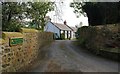
7
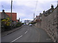
Back Street in Upper Largo
The road leading to the School and the Cemetery.
Image: © Sandy Gemmill
Taken: 10 Apr 2007
0.03 miles
8
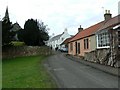
The Kirk of Kirkton of Largo
Upper Largo is also known as Kirkton of Largo and this street leads past the said Kirk.
Image: © James Allan
Taken: 17 Feb 2009
0.03 miles
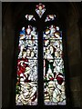
10
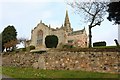
Largo and Newburn Parish Church, Upper Largo
There has been a church on this site since 1160. The current building is rather more modern although the tower dates back to the 1620s.
See Upper Largo article https://www.geograph.org.uk/article/Upper-Largo
Image: © Bill Kasman
Taken: 18 Apr 2019
0.03 miles