IMAGES TAKEN NEAR TO
Seatoun Place, LEVEN, KY8 6BL

Introduction

This page details the photographs taken nearby to Seatoun Place, KY8 6BL by members of the Geograph project.

The Geograph project started in 2005 with the aim of publishing, organising and preserving representative images for every square kilometre of Great Britain, Ireland and the Isle of Man.

There are currently over 7.5m images from over14,400 individuals and you can help contribute to the project by visiting https://www.geograph.org.uk

Image Map


Images are licensed for reuse under creativecommons.org/licenses/by-sa/2.0
Notes
  • Clicking on the map will re-center to the selected point.
  • The higher the marker number, the further away the image location is from the centre of the postcode.

Image Listing (311 Images Found)

Images are licensed for reuse under creativecommons.org/licenses/by-sa/2.0
  • ...
Image
Details
Distance
1
Seatoun Place, Largo
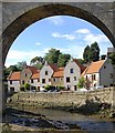
A short Cul-de-sac with smart homes by the edge of the river. Viewed through an arch of the old railway line.
Image: © Jim Bain Taken: 14 Jul 2007
0.01 miles
2
Seaton Place
Row of houses above the Keil Burn.
Image: © Oliver Dixon Taken: 26 Mar 2022
0.03 miles
3
New housing off Harbour Wynd
Large, posh new housing being built in Lower Largo, in the development called Crusoe Court.
Image: © Richard Law Taken: 3 May 2022
0.03 miles
4
Burnbrae Terrace, Lower Largo
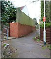
Burnbrae Terrace runs behind the building in this image Image and divides into two footpaths both of which reach Lundin Links. See Lower Largo article https://www.geograph.org.uk/article/Lower-Largo-and-the-Serpentine-Walk
Image: © Bill Kasman Taken: 11 Apr 2019
0.04 miles
5
Demolition site, Lower Largo
A few hundred metres up Harbour Wynd from the Crusoe Hotel this pile of rubble is the last remnants of Lower Largo Gas Works. It has been demolished to make way for new housing. See Lower Largo article https://www.geograph.org.uk/article/Lower-Largo-and-the-Serpentine-Walk
Image: © Bill Kasman Taken: 24 Mar 2019
0.04 miles
6
New houses off Harbour Wynd
The upper part of a new housing development on a site which previously had an old industrial unit on it. There are several more being built just off-shot to the left Image
Image: © Richard Law Taken: 3 May 2022
0.04 miles
7
House building at Crusoe Court
The construction of several large, rather posh new houses is underway on a recently-cleared site off Harbour Wynd. It's a fair bet they will end up very similar to Image just up the road.
Image: © Richard Law Taken: 3 May 2022
0.04 miles
8
Burnbrae Terrace, Lower Largo
Burnbrae Terrace divides into two behind the building in this image Image Both paths reach Lundin Links. The red notice on the lamp post beseeches dog walkers to pick up their dog's poo! See Lower Largo article https://www.geograph.org.uk/article/Lower-Largo-and-the-Serpentine-Walk
Image: © Bill Kasman Taken: 12 Apr 2019
0.04 miles
9
View through the old viaduct, Lower Largo
Houses on Seatoun Place seen from beside the Hatton Burn, through one of the arches of the Category B listed viaduct, built 1856-7 by East of Fife Railway Company. The line to St Andrews closed to all traffic in 1966.
Image: © Richard Sutcliffe Taken: 23 Mar 2019
0.04 miles
10
Millstones in Lower Largo
These millstones in Seaton Place have an interesting history. In the early 1950s a caravan park occupied this site. These millstones (from a mill which was previously located here) were buried during the preparation of the caravan site and unearthed again when the caravan site was redeveloped for the building of Seatoun Place in 1982. They are 2.37m in diameter and 0.45m wide and now serve as a reminder of the areas' industrial heritage. See Lower Largo article https://www.geograph.org.uk/article/Lower-Largo-and-the-Serpentine-Walk
Image: © Bill Kasman Taken: 4 Apr 2019
0.04 miles
  • ...