IMAGES TAKEN NEAR TO
Links Road, LEVEN, KY8 6AG
Introduction
This page details the photographs taken nearby to Links Road, KY8 6AG by members of the Geograph project.
The Geograph project started in 2005 with the aim of publishing, organising and preserving representative images for every square kilometre of Great Britain, Ireland and the Isle of Man.

There are currently over 7.5m images from over14,400 individuals and you can help contribute to the project by visiting https://www.geograph.org.uk
Image Map
Images are licensed for reuse under creativecommons.org/licenses/by-sa/2.0
Notes
- Clicking on the map will re-center to the selected point.
- The higher the marker number, the further away the image location is from the centre of the postcode.
Image Listing (73 Images Found)
Images are licensed for reuse under creativecommons.org/licenses/by-sa/2.0
Image
Details
Distance
1
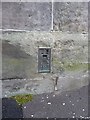
OS flush bracket - Lower Largo
Flush Bracket G807, affixed to the wall of the Post Office at the corner of Links Road; it was originally levelled in 1956 at 27.566m above Ordnance Datum Newlyn.
Image: © Richard Law
Taken: 6 Jun 2015
0.01 miles
2
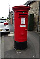
Elizabethan postbox on Leven Road, Lundin Links
Postbox No. KY8 188.
Image: © JThomas
Taken: 21 Jul 2021
0.02 miles
3
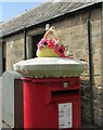
Pillar box cosy?
Looking like a tea cosy this curious decoration, which has obviously had a fair amount of time and skill invested in it, was on top of a pillar box in Links Road, Lundin Links.
Image: © Bill Kasman
Taken: 7 Sep 2022
0.02 miles
4
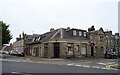
Lundin Links Pharmacy
The former Post Office.
Image: © JThomas
Taken: 21 Jul 2021
0.02 miles
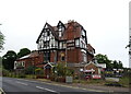
5
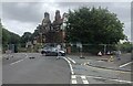
Lundin Links Hotel
The imposing-looking building of the Lundin Links Hotel was ravaged by fire on the evening of Thursday August 18th. A listed building, the hotel had been closed for several years https://www.geograph.org.uk/photo/7165038 and was slated for conversion into flatted properties. Sadly, the building is beyond recovery and will be demolished and, until such time as that happens, the main road through the village (A915) has been closed with diversions put into place. Police believe the fire was started deliberately.
Image: © Bill Kasman
Taken: 23 Aug 2022
0.03 miles
6
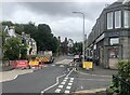
Road closed
The imposing-looking building of the Lundin Links Hotel (centre image) was ravaged by fire on the evening of Thursday August 18th https://www.geograph.org.uk/photo/7263149 A listed building, the hotel had been closed for several years https://www.geograph.org.uk/photo/7165038 and was slated for conversion into flatted properties. Sadly, the building is beyond recovery and will be demolished and, until such time as that happens, the main road through the village (A915) has been closed with diversions put into place. Police believe the fire was started deliberately.
Image: © Bill Kasman
Taken: 23 Aug 2022
0.03 miles
7

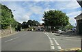
Lundin Links Hotel
After being destroyed by fire this hotel was demolished https://www.geograph.org.uk/photo/7263149
Image: © Bill Kasman
Taken: 7 Sep 2022
0.03 miles
8
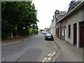
Lundin Links Hotel
After being destroyed by fire this hotel was demolished https://www.geograph.org.uk/photo/7263149
Image: © Bill Kasman
Taken: 7 Sep 2022
0.03 miles
10
The Lundin Links Hotel
The hotel closed its doors in 2014.
Image: © JThomas
Taken: 21 Jul 2021
0.03 miles