IMAGES TAKEN NEAR TO
Kennoway, LEVEN, KY8 5SN
Introduction
This page details the photographs taken nearby to KY8 5SN by members of the Geograph project.
The Geograph project started in 2005 with the aim of publishing, organising and preserving representative images for every square kilometre of Great Britain, Ireland and the Isle of Man.

There are currently over 7.5m images from over14,400 individuals and you can help contribute to the project by visiting https://www.geograph.org.uk
Image Map
Images are licensed for reuse under creativecommons.org/licenses/by-sa/2.0
Notes
- Clicking on the map will re-center to the selected point.
- The higher the marker number, the further away the image location is from the centre of the postcode.
Image Listing (3 Images Found)
Images are licensed for reuse under creativecommons.org/licenses/by-sa/2.0
Image
Details
Distance
2
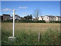
Springbank
A gas pipeline marker on Cupar Road.
Image: © Richard Webb
Taken: 26 Aug 2012
0.24 miles
3
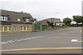
Stuart's the Bakers
The green shutters belong to a branch of Stuart's the Bakers which has been temporarily closed. This is one of several small branches of this baker which have been closed as a result of the current coronavirus pandemic. Most should reopen again but at least one https://www.geograph.org.uk/photo/6555702 has been taken over by another business.
Image: © Bill Kasman
Taken: 30 Aug 2020
0.24 miles