IMAGES TAKEN NEAR TO
Station Road, LEVEN, KY8 5RJ
Introduction
This page details the photographs taken nearby to Station Road, KY8 5RJ by members of the Geograph project.
The Geograph project started in 2005 with the aim of publishing, organising and preserving representative images for every square kilometre of Great Britain, Ireland and the Isle of Man.

There are currently over 7.5m images from over14,400 individuals and you can help contribute to the project by visiting https://www.geograph.org.uk
Image Map
Images are licensed for reuse under creativecommons.org/licenses/by-sa/2.0
Notes
- Clicking on the map will re-center to the selected point.
- The higher the marker number, the further away the image location is from the centre of the postcode.
Image Listing (39 Images Found)
Images are licensed for reuse under creativecommons.org/licenses/by-sa/2.0
Image
Details
Distance
1
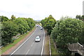
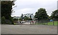
The A911
From the footbridge in this image Image
Image: © Bill Kasman
Taken: 10 Aug 2018
0.02 miles
2
Footbridge over A911
At the end of Station Road there is a footbridge which takes pedestrians over the main road to the village of Windygates.
Image: © Bill Kasman
Taken: 10 Aug 2018
0.04 miles
3
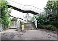
Footbridge over A911
There are two ways to cross this footbridge which leads to the village of Windygates. The left hand way is intended for cyclists who can more easily push their bicycles along rather than using the pedestrian steps on the right.
Image: © Bill Kasman
Taken: 10 Aug 2018
0.04 miles
4
Footbridge over A911
Viewed from a path at the side of the A911 this footbridge leads from Station Road to the village of Windygates.
Image: © Bill Kasman
Taken: 10 Aug 2018
0.04 miles
5
Diageo distillery
Off Station Road is this staff car park for the distillery at Cameron Bridge.
Image: © Bill Kasman
Taken: 10 Aug 2018
0.06 miles
6
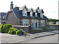
Monrepos & Mariposa
These cottages are described in their collective 1996 Category C listing https://portal.historicenvironment.scot/apex/f?p=1505:300:::::VIEWTYPE,VIEWREF:designation,LB43017 & https://britishlistedbuildings.co.uk/200389338-monrepos-8-station-road-windygates-markinch as "semi detached pair of single storey with attic, 2 bay cottages with dormer windows. Red brick with contrasting rusticated ashlar quoins" but later noted that they would be much improved by reinstatement of appropriate windows & doors. At the time of the photo, that comment could probably be extended to say that the nearer one would benefit from a lick of paint on the bargeboards and around the dormer windows. The listing includes the boundary walls, gates and railings etc (but not my bike!)
Image: © Richard Law
Taken: 9 Jun 2024
0.07 miles
7
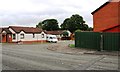
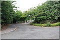
Bridgend Gardens
Off Station Road near the Cameron Bridge distillery.
Image: © Bill Kasman
Taken: 10 Aug 2018
0.08 miles
8
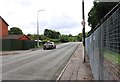
Driving lessons
This driving instruction car is in Station Road near the Diageo distillery at Cameron Bridge.
Image: © Bill Kasman
Taken: 10 Aug 2018
0.10 miles
9
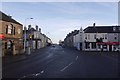
Crossroads, Windygates
Looking down Leven Road from the Milton Road side of the crossroads.
Image: © Richard Webb
Taken: 14 Dec 2016
0.11 miles
10
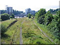
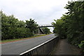
Cameron Bridge station and distillery
Cameron Bridge station, on a branch that ran from Thornton Junction to Leven and then round the East Neuk of Fife to St Andrews, was closed to passengers in October 1969. Freight trains to Methil Power station continued to run past the station until the 1990s but since then, except for a trial train run a few years ago in the hope of a distillery traffic contract, the line has been unused. The right-hand platform was the passenger platform and the shorter one to the left was used for loading and unloading goods traffic. This photograph was taken from Station Road bridge. A previous Geograph photo http://www.geograph.org.uk/photo/625843 showing an enthusiasts' train at the platform, was taken from a footbridge at the far end of the station, which carried a public right of way that has been swallowed up by expansion of the distillery since 1984.
Image: © A-M-Jervis
Taken: 23 Jul 2007
0.12 miles