IMAGES TAKEN NEAR TO
LEVEN, KY8 5RH
Introduction
This page details the photographs taken nearby to KY8 5RH by members of the Geograph project.
The Geograph project started in 2005 with the aim of publishing, organising and preserving representative images for every square kilometre of Great Britain, Ireland and the Isle of Man.

There are currently over 7.5m images from over14,400 individuals and you can help contribute to the project by visiting https://www.geograph.org.uk
Image Map
Images are licensed for reuse under creativecommons.org/licenses/by-sa/2.0
Notes
- Clicking on the map will re-center to the selected point.
- The higher the marker number, the further away the image location is from the centre of the postcode.
Image Listing (5 Images Found)
Images are licensed for reuse under creativecommons.org/licenses/by-sa/2.0
Image
Details
Distance
1
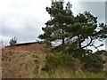
Pines by the barns
Farm buildings at Duniface,
Image: © James Allan
Taken: 2 Apr 2013
0.06 miles
2
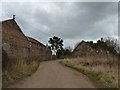
Farm buildings - some derelict
At Duniface Farm.
Image: © James Allan
Taken: 2 Apr 2013
0.07 miles
3
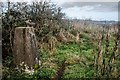
Trigpoint, Duniface Hill
This trigpoint sits on the NO3501/NO3401 gridline, so it was difficult to know which square it was in. Trigpointing UK, however, sites it within this gridsquare, so that is good enough for me!
Looking north towards Kennoway.
Image: © Becky Williamson
Taken: 5 Nov 2019
0.16 miles
4
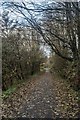
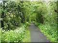
An autumn walk along the disused railway track, Balcurvie
Image: © Becky Williamson
Taken: 5 Nov 2019
0.20 miles
5
Disused railway track, Balcurvie
Part of the East Fife Central Branch of the North British Railway company, later the LNER, which left the main line just SE of this point, and ran (generally) northeastwards through Letham, Montrave and Largoward to Lochty. It was built in the 1890s as a mineral line to serve coalfields inland from the coast, but never proved economically successful, even when running just 3 trains a week and closed in the 1960s.
Image: © Richard Law
Taken: 5 Jun 2019
0.20 miles