IMAGES TAKEN NEAR TO
LEVEN, KY8 5PZ
Introduction
This page details the photographs taken nearby to KY8 5PZ by members of the Geograph project.
The Geograph project started in 2005 with the aim of publishing, organising and preserving representative images for every square kilometre of Great Britain, Ireland and the Isle of Man.

There are currently over 7.5m images from over14,400 individuals and you can help contribute to the project by visiting https://www.geograph.org.uk
Image Map
Images are licensed for reuse under creativecommons.org/licenses/by-sa/2.0
Notes
- Clicking on the map will re-center to the selected point.
- The higher the marker number, the further away the image location is from the centre of the postcode.
Image Listing (21 Images Found)
Images are licensed for reuse under creativecommons.org/licenses/by-sa/2.0
Image
Details
Distance
1
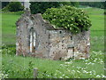
Lundin Tower Doocot
Described in its 1984 Category B listing https://britishlistedbuildings.co.uk/200341189-lundin-tower-dovecot-largo#.XT6Z8OhKhPY as 'Still inhabited" (by pigeons, presumably). The situation has clearly now changed and the 18th century Gothic building is rapidly becoming a sad ruin.
Image: © Richard Law
Taken: 7 Jun 2019
0.03 miles
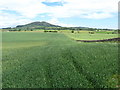
4
Looking towards Pilmuir Farm
Country road leading to the farm in Fife.
Image: © James Denham
Taken: 22 Jun 2009
0.07 miles
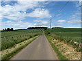
5
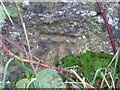
Benchmark on minor road near Lundin Links
Ordnance Survey benchmark on wall, described on database at https://www.bench-marks.org.uk/bm137496. See also Image
Image: © Becky Williamson
Taken: 29 Nov 2020
0.08 miles
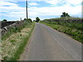
6
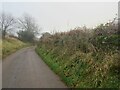
Single track road between Lundin Links and Pilmuir
There is an Ordnance Survey benchmark on the wall on the right, barely visible through the vegetation and not visible in this photograph. See Image
Image: © Becky Williamson
Taken: 29 Nov 2020
0.08 miles


9

Combine harvester in action
Harvesting a wheatfield near Leven.
Image: © Bill Kasman
Taken: 3 Sep 2017
0.09 miles
10
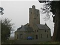
Lundin Tower and private house
The tower is all that remains of the former Lundin House. The House was demolished in 1876. Although the tower itself is thought to date from the late 16th or early 17th century, it has had many alterations since.
For an excellent description of this tower, visit https://lundinlinks.weebly.com/blog/lundin-tower.
Image: © Becky Williamson
Taken: 29 Nov 2020
0.09 miles