IMAGES TAKEN NEAR TO
LEVEN, KY8 5PE
Introduction
This page details the photographs taken nearby to KY8 5PE by members of the Geograph project.
The Geograph project started in 2005 with the aim of publishing, organising and preserving representative images for every square kilometre of Great Britain, Ireland and the Isle of Man.

There are currently over 7.5m images from over14,400 individuals and you can help contribute to the project by visiting https://www.geograph.org.uk
Image Map
Images are licensed for reuse under creativecommons.org/licenses/by-sa/2.0
Notes
- Clicking on the map will re-center to the selected point.
- The higher the marker number, the further away the image location is from the centre of the postcode.
Image Listing (5 Images Found)
Images are licensed for reuse under creativecommons.org/licenses/by-sa/2.0
Image
Details
Distance
1
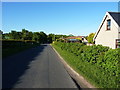
Cottages near Annfield
On the lane from Pratis to New Gilston
Image: © Richard Law
Taken: 10 Jun 2015
0.02 miles

3
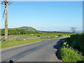
The road junction at Annfield
Largo Law forms the backdrop of this shot, with the guano-covered Bass Rock Image visible on the far side of the Firth of Forth.
Image: © Richard Law
Taken: 10 Jun 2015
0.21 miles
4
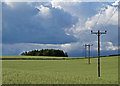
Farmland near Annfield
A line of electricity poles crossing a farmed hillside near Annfield, with storm clouds filling the sky.
Image: © William Starkey
Taken: 30 Jun 2011
0.21 miles