IMAGES TAKEN NEAR TO
Kennoway Road, KY8 5FS
Introduction
This page details the photographs taken nearby to Kennoway Road, KY8 5FS by members of the Geograph project.
The Geograph project started in 2005 with the aim of publishing, organising and preserving representative images for every square kilometre of Great Britain, Ireland and the Isle of Man.

There are currently over 7.5m images from over14,400 individuals and you can help contribute to the project by visiting https://www.geograph.org.uk
Image Map
Images are licensed for reuse under creativecommons.org/licenses/by-sa/2.0
Notes
- Clicking on the map will re-center to the selected point.
- The higher the marker number, the further away the image location is from the centre of the postcode.
Image Listing (18 Images Found)
Images are licensed for reuse under creativecommons.org/licenses/by-sa/2.0
Image
Details
Distance
1
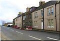
Propped up house
On that part of Leven Road, Windygates, known as Douglas Terrace this house is in danger of collapse and has been supported by props for some time. The house is unoccupied and is for sale but apparently there is a dispute as to who should pay for repairs.
Image: © Bill Kasman
Taken: 11 Mar 2020
0.06 miles
2
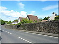
Boundary wall to Durie Vale House, Windygates
The rubblestone wall here is the northern boundary wall to the estate of a late 18th century former farmhouse, the harled & whitewashed gable of which is visible on the right. Much of the land around the house has now been developed for housing, but the boundary wall remains, and forms part of the 1996 Category B listing of the house https://portal.historicenvironment.scot/apex/f?p=1505:300:::::VIEWTYPE,VIEWREF:designation,LB43012 & https://britishlistedbuildings.co.uk/200389331-house-durie-vale-windygates-markinch
Image: © Richard Law
Taken: 9 Jun 2024
0.08 miles
3
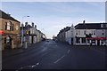
Crossroads, Windygates
Looking down Leven Road from the Milton Road side of the crossroads.
Image: © Richard Webb
Taken: 14 Dec 2016
0.10 miles
4
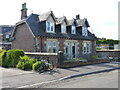
Monrepos & Mariposa
These cottages are described in their collective 1996 Category C listing https://portal.historicenvironment.scot/apex/f?p=1505:300:::::VIEWTYPE,VIEWREF:designation,LB43017 & https://britishlistedbuildings.co.uk/200389338-monrepos-8-station-road-windygates-markinch as "semi detached pair of single storey with attic, 2 bay cottages with dormer windows. Red brick with contrasting rusticated ashlar quoins" but later noted that they would be much improved by reinstatement of appropriate windows & doors. At the time of the photo, that comment could probably be extended to say that the nearer one would benefit from a lick of paint on the bargeboards and around the dormer windows. The listing includes the boundary walls, gates and railings etc (but not my bike!)
Image: © Richard Law
Taken: 9 Jun 2024
0.13 miles
5
The A911
From the footbridge in this image Image
Image: © Bill Kasman
Taken: 10 Aug 2018
0.17 miles
6

Colourful car park
Alongside a roundabout junction on the A911, A915 and A916 roads.
Image: © James Allan
Taken: 11 Aug 2012
0.17 miles
7
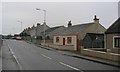
Looking down Kennoway road to Windygates Cross
This is the A916, a busy link between Kirkcaldy and Cupar.
Image: © Ian Cowie
Taken: 25 Dec 2005
0.18 miles
8

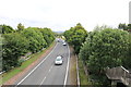
Barley twixt the trees
Probably about to become raw material for the Diagio grain whisky distillery at nearby Cameron Bridge.
Image: © James Allan
Taken: 11 Aug 2012
0.18 miles
9
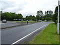
Roundabout on the A915
The A915 here is the main Fife Coast Road, running basically northeast-southwest between Kirkcaldy and Leven. The roundabout also features the A916 north to Cupar and the A911 west to Glenrothes.
Image: © Richard Law
Taken: 5 Jun 2019
0.18 miles
10
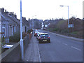
Windygates.
Bungalows on the road to Kennoway. Looking south.
Image: © Richard Webb
Taken: 12 Feb 2006
0.18 miles