IMAGES TAKEN NEAR TO
Cameron Close, LEVEN, KY8 5FN
Introduction
This page details the photographs taken nearby to Cameron Close, KY8 5FN by members of the Geograph project.
The Geograph project started in 2005 with the aim of publishing, organising and preserving representative images for every square kilometre of Great Britain, Ireland and the Isle of Man.

There are currently over 7.5m images from over14,400 individuals and you can help contribute to the project by visiting https://www.geograph.org.uk
Image Map
Images are licensed for reuse under creativecommons.org/licenses/by-sa/2.0
Notes
- Clicking on the map will re-center to the selected point.
- The higher the marker number, the further away the image location is from the centre of the postcode.
Image Listing (5 Images Found)
Images are licensed for reuse under creativecommons.org/licenses/by-sa/2.0
Image
Details
Distance
1
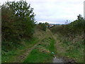
Drummaird track
Track linking Drummaird farm and Bonnybank village.
Image: © James Allan
Taken: 30 Oct 2006
0.09 miles
2
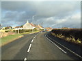
Bonnybank
Road into village from Kennoway
Image: © James Allan
Taken: 20 Jan 2006
0.10 miles
4
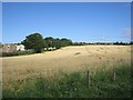
Road to Balgriebank
Signposted path to Porter's Brae via Balgriebank. There is a small wind turbine on a spur.
Image: © Richard Webb
Taken: 10 Feb 2012
0.21 miles
5
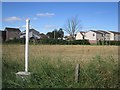
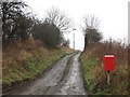
Springbank
A gas pipeline marker on Cupar Road.
Image: © Richard Webb
Taken: 26 Aug 2012
0.22 miles