IMAGES TAKEN NEAR TO
Myreside Avenue, LEVEN, KY8 5EP
Introduction
This page details the photographs taken nearby to Myreside Avenue, KY8 5EP by members of the Geograph project.
The Geograph project started in 2005 with the aim of publishing, organising and preserving representative images for every square kilometre of Great Britain, Ireland and the Isle of Man.

There are currently over 7.5m images from over14,400 individuals and you can help contribute to the project by visiting https://www.geograph.org.uk
Image Map
Images are licensed for reuse under creativecommons.org/licenses/by-sa/2.0
Notes
- Clicking on the map will re-center to the selected point.
- The higher the marker number, the further away the image location is from the centre of the postcode.
Image Listing (5 Images Found)
Images are licensed for reuse under creativecommons.org/licenses/by-sa/2.0
Image
Details
Distance
1
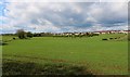
Kennoway
From the path which runs behind the Diageo distillery in Leven.
Image: © Bill Kasman
Taken: 4 May 2020
0.11 miles
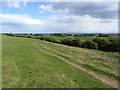
2
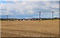
Kennoway
This is the view of Kennoway, Fife, from the path which runs alongside the perimeter fence of the Diageo distillery in Leven. The Lomond Hills are visible in the distance.
Image: © Bill Kasman
Taken: 4 May 2020
0.12 miles
3
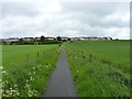
Path across fields
Heading for the housing estates of Kennoway.
Image: © Richard Law
Taken: 5 Jun 2019
0.19 miles
5
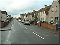
Path below Castle Terrace
The path descends from a residential area in Kennoway to some young woodland.
Image: © Richard Webb
Taken: 15 May 2012
0.23 miles