IMAGES TAKEN NEAR TO
Balcurvie Road, LEVEN, KY8 5DX
Introduction
This page details the photographs taken nearby to Balcurvie Road, KY8 5DX by members of the Geograph project.
The Geograph project started in 2005 with the aim of publishing, organising and preserving representative images for every square kilometre of Great Britain, Ireland and the Isle of Man.

There are currently over 7.5m images from over14,400 individuals and you can help contribute to the project by visiting https://www.geograph.org.uk
Image Map
Images are licensed for reuse under creativecommons.org/licenses/by-sa/2.0
Notes
- Clicking on the map will re-center to the selected point.
- The higher the marker number, the further away the image location is from the centre of the postcode.
Image Listing (6 Images Found)
Images are licensed for reuse under creativecommons.org/licenses/by-sa/2.0
Image
Details
Distance
1
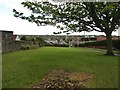
Green space, Balcurvie
A small public green space above Windygates.
Image: © Richard Webb
Taken: 15 May 2012
0.08 miles
2
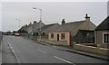
Windygates.
Bungalows on the road to Kennoway. Looking south.
Image: © Richard Webb
Taken: 12 Feb 2006
0.17 miles
3
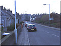
Looking down Kennoway road to Windygates Cross
This is the A916, a busy link between Kirkcaldy and Cupar.
Image: © Ian Cowie
Taken: 25 Dec 2005
0.19 miles
4
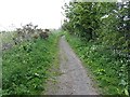
Path, Balcurvie
A well used path which obviously is not plagued by obstructions for horses.
Image: © Richard Webb
Taken: 15 May 2012
0.24 miles
5
Propped up house
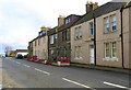
On that part of Leven Road, Windygates, known as Douglas Terrace this house is in danger of collapse and has been supported by props for some time. The house is unoccupied and is for sale but apparently there is a dispute as to who should pay for repairs.
Image: © Bill Kasman
Taken: 11 Mar 2020
0.24 miles
6
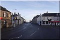
Crossroads, Windygates
Looking down Leven Road from the Milton Road side of the crossroads.
Image: © Richard Webb
Taken: 14 Dec 2016
0.25 miles