IMAGES TAKEN NEAR TO
Kennoway Burns, LEVEN, KY8 5BT
Introduction
This page details the photographs taken nearby to Kennoway Burns, KY8 5BT by members of the Geograph project.
The Geograph project started in 2005 with the aim of publishing, organising and preserving representative images for every square kilometre of Great Britain, Ireland and the Isle of Man.

There are currently over 7.5m images from over14,400 individuals and you can help contribute to the project by visiting https://www.geograph.org.uk
Image Map
Images are licensed for reuse under creativecommons.org/licenses/by-sa/2.0
Notes
- Clicking on the map will re-center to the selected point.
- The higher the marker number, the further away the image location is from the centre of the postcode.
Image Listing (5 Images Found)
Images are licensed for reuse under creativecommons.org/licenses/by-sa/2.0
Image
Details
Distance
1
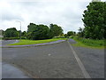
The western end of the track to Cock-ma-Lane
The track which runs behind the extensive Diageo site, and then across fields, emerges onto the A916 Sandy Brae road about here.
Image: © Richard Law
Taken: 5 Jun 2019
0.15 miles
2
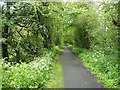
Disused railway track, Balcurvie
Part of the East Fife Central Branch of the North British Railway company, later the LNER, which left the main line just SE of this point, and ran (generally) northeastwards through Letham, Montrave and Largoward to Lochty. It was built in the 1890s as a mineral line to serve coalfields inland from the coast, but never proved economically successful, even when running just 3 trains a week and closed in the 1960s.
Image: © Richard Law
Taken: 5 Jun 2019
0.19 miles
3
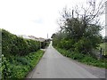
Fa-latch Road
A straight minor road with a bit of an equestrian following.
Image: © Richard Webb
Taken: 15 May 2012
0.21 miles
4
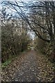
An autumn walk along the disused railway track, Balcurvie
Image: © Becky Williamson
Taken: 5 Nov 2019
0.22 miles
5

Wild Poppy
Wild poppy growing on old railway track.
Image: © Duncan MacMillan
Taken: 8 Jul 2005
0.23 miles