IMAGES TAKEN NEAR TO
Scoonie Drive, LEVEN, KY8 4SL
Introduction
This page details the photographs taken nearby to Scoonie Drive, KY8 4SL by members of the Geograph project.
The Geograph project started in 2005 with the aim of publishing, organising and preserving representative images for every square kilometre of Great Britain, Ireland and the Isle of Man.

There are currently over 7.5m images from over14,400 individuals and you can help contribute to the project by visiting https://www.geograph.org.uk
Image Map
Images are licensed for reuse under creativecommons.org/licenses/by-sa/2.0
Notes
- Clicking on the map will re-center to the selected point.
- The higher the marker number, the further away the image location is from the centre of the postcode.
Image Listing (69 Images Found)
Images are licensed for reuse under creativecommons.org/licenses/by-sa/2.0
Image
Details
Distance
2
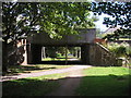
The former railway line goes under the Scoonie Road bridge
The route of the former railway line from Leven. At this point the railway line(according to the OS 7th series) is single track.
Image: © Sandy Gemmill
Taken: 9 Aug 2018
0.05 miles
4
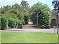
Footpath following the former railway line
Footpath following the Leven to Lundin Links railway line.
Image: © Sandy Gemmill
Taken: 9 Aug 2018
0.10 miles
5

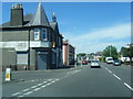
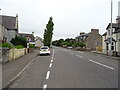
Maitland Street, Leven
To the east of Scoonie Road ( A955 )
Image: © Jim Bain
Taken: 21 Jun 2007
0.10 miles
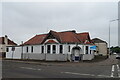
7
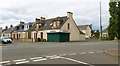
Stuart's the Bakers
The green shutters belong to a branch of Stuart's the Bakers which has been temporarily closed. This is one of several small branches of this baker which have been closed as a result of the current coronavirus pandemic. Most should reopen again but at least one https://www.geograph.org.uk/photo/6555702 has been taken over by another business.
Image: © Bill Kasman
Taken: 30 Aug 2020
0.10 miles
9
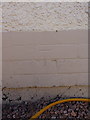
OS benchmark - Leven, 25 Scoonie Drive
An OS cutmark low on the brickwork at the side of no 25 Scoonie Drive; originally levelled at 9.229m above Ordnance Datum Newlyn.
Image: © Richard Law
Taken: 11 Jun 2015
0.11 miles
10
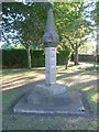
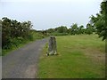
Leven mercat cross, grounds of Carberry House
The cross stood on Carpenters Brae until its removal in 1767. After spells at other locations in the town it was partially reconstructed and re-erected in the grounds of a Fife Council Social Work Centre.
Image: © kim traynor
Taken: 7 Jun 2013
0.14 miles