IMAGES TAKEN NEAR TO
Lime Grove, LEVEN, KY8 2JR
Introduction
This page details the photographs taken nearby to Lime Grove, KY8 2JR by members of the Geograph project.
The Geograph project started in 2005 with the aim of publishing, organising and preserving representative images for every square kilometre of Great Britain, Ireland and the Isle of Man.

There are currently over 7.5m images from over14,400 individuals and you can help contribute to the project by visiting https://www.geograph.org.uk
Image Map
Images are licensed for reuse under creativecommons.org/licenses/by-sa/2.0
Notes
- Clicking on the map will re-center to the selected point.
- The higher the marker number, the further away the image location is from the centre of the postcode.
Image Listing (5 Images Found)
Images are licensed for reuse under creativecommons.org/licenses/by-sa/2.0
Image
Details
Distance
1
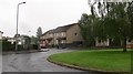
Rowan Crescent, Methilhill
A meeting of five residential roads.
Image: © Richard Webb
Taken: 30 May 2012
0.12 miles
3
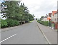
Sea Road towards Methilhill Primary School
From its junction with Main Street (B932) Sea Road provides access to Methilhill Primary School. For a view in the opposite direction see this photo Image]
Image: © Bill Kasman
Taken: 30 Aug 2015
0.18 miles
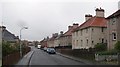
4
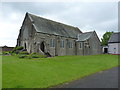
Methilhill and Denbeath Parish Church
Located on Chemiss Road, Methilhill
Image: © Richard Law
Taken: 5 Jun 2019
0.24 miles
5
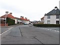
Sycamore Avenue, Methilhill
Typical post war housing development.
Image: © Jim Bain
Taken: 19 Mar 2006
0.25 miles