IMAGES TAKEN NEAR TO
Markinch, GLENROTHES, KY7 6NZ
Introduction
This page details the photographs taken nearby to KY7 6NZ by members of the Geograph project.
The Geograph project started in 2005 with the aim of publishing, organising and preserving representative images for every square kilometre of Great Britain, Ireland and the Isle of Man.

There are currently over 7.5m images from over14,400 individuals and you can help contribute to the project by visiting https://www.geograph.org.uk
Image Map
Images are licensed for reuse under creativecommons.org/licenses/by-sa/2.0
Notes
- Clicking on the map will re-center to the selected point.
- The higher the marker number, the further away the image location is from the centre of the postcode.
Image Listing (7 Images Found)
Images are licensed for reuse under creativecommons.org/licenses/by-sa/2.0
Image
Details
Distance
3
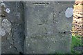
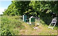
Benchmark on wall near Bellfield
Ordnance Survey benchmark, described on database at https://www.bench-marks.org.uk/bm116024. See also Image
Image: © Becky Williamson
Taken: 4 Feb 2020
0.23 miles
4
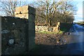
Wall and road near Bellfield
There is an Ordnance Survey benchmark on this wall. See Image
Image: © Becky Williamson
Taken: 4 Feb 2020
0.23 miles
5
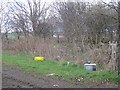
What's on the other side?
Dumped rubbish near Milltown of Balgonie
Image: © Richard Webb
Taken: 26 Apr 2013
0.23 miles
6
Beehives
These beehives are in a field just off the minor road which leaves Markinch at the railway station. They are probably the western or European honeybee (Apis mellifera) but I didn't want to get close enough to be certain!
Image: © Bill Kasman
Taken: 6 Jun 2020
0.23 miles
