IMAGES TAKEN NEAR TO
Markinch, GLENROTHES, KY7 6JY
Introduction
This page details the photographs taken nearby to KY7 6JY by members of the Geograph project.
The Geograph project started in 2005 with the aim of publishing, organising and preserving representative images for every square kilometre of Great Britain, Ireland and the Isle of Man.

There are currently over 7.5m images from over14,400 individuals and you can help contribute to the project by visiting https://www.geograph.org.uk
Image Map
Images are licensed for reuse under creativecommons.org/licenses/by-sa/2.0
Notes
- Clicking on the map will re-center to the selected point.
- The higher the marker number, the further away the image location is from the centre of the postcode.
Image Listing (14 Images Found)
Images are licensed for reuse under creativecommons.org/licenses/by-sa/2.0
Image
Details
Distance
1
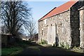
Barn at Dalginch
The Fife Pilgrim Way goes past this small hamlet.
Image: © Becky Williamson
Taken: 4 Feb 2020
0.01 miles
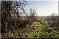
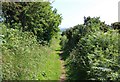
2
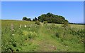
Not the Braes Loan Trail!
This path branches off from the Braes Loan Trail and heads to Dalginch Farm. The small sign on a post just visible on the left states that this path isn't a right-of-way.
Image: © Bill Kasman
Taken: 25 Jun 2020
0.08 miles
3
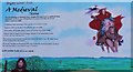
Information Board
On the Braes Loan Trail this information board harks back to bygone days.
Image: © Bill Kasman
Taken: 25 Jun 2020
0.10 miles
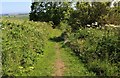
4
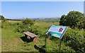
The Braes Loan Trail
At a strategic point on the trail a great view over the Fife countryside towards the Firth of Forth can be had if the weather is clear. For a closer look at the information board see this image https://www.geograph.org.uk/photo/6519140
The Braes Loan Trail can be followed as a Geo-Trip http://www.geograph.org.uk/geotrips/1672
Image: © Bill Kasman
Taken: 25 Jun 2020
0.11 miles
5
The Braes Loan Trail
The trail heads towards The Mires where cattle were once grazed.
Image: © Bill Kasman
Taken: 25 Jun 2020
0.11 miles
6
Information board and bench at Dalginch
This is on the Fife Pilgrim Way. There is an Ordnance Survey benchmark on the very old wall on the left. See Image
Image: © Becky Williamson
Taken: 4 Feb 2020
0.11 miles
7
Benchmark on old wall at Dalginch
Ordnance Survey benchmark, described on database at https://www.bench-marks.org.uk/bm116025. See also Image
Image: © Becky Williamson
Taken: 4 Feb 2020
0.11 miles
8
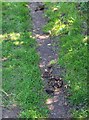
Horse droppings!
On the Braes Loan Trail. I didn't meet the culprit though!
Image: © Bill Kasman
Taken: 25 Jun 2020
0.12 miles
9
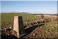
Dalginch trigpoint
East Lomond visible in the distance.
Image: © Becky Williamson
Taken: 4 Feb 2020
0.13 miles
10
The Braes Loan Trail
This part of the trail was once used to drive cattle from the common grazings near Star of Markinch southwards to the meadows where Brunton Mill once stood.
Image: © Bill Kasman
Taken: 25 Jun 2020
0.13 miles