IMAGES TAKEN NEAR TO
Rothes Park, GLENROTHES, KY6 3LL
Introduction
This page details the photographs taken nearby to Rothes Park, KY6 3LL by members of the Geograph project.
The Geograph project started in 2005 with the aim of publishing, organising and preserving representative images for every square kilometre of Great Britain, Ireland and the Isle of Man.

There are currently over 7.5m images from over14,400 individuals and you can help contribute to the project by visiting https://www.geograph.org.uk
Image Map
Images are licensed for reuse under creativecommons.org/licenses/by-sa/2.0
Notes
- Clicking on the map will re-center to the selected point.
- The higher the marker number, the further away the image location is from the centre of the postcode.
Image Listing (15 Images Found)
Images are licensed for reuse under creativecommons.org/licenses/by-sa/2.0
Image
Details
Distance
1
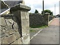
Gateposts to Leslie Cemetery
There is a damaged Ordnance Survey benchmark on the left hand post. See Image
Image: © Becky Williamson
Taken: 10 Aug 2021
0.12 miles
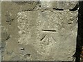
2
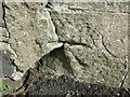
Damaged benchmark at Leslie Cemetery
Damaged Ordnance Survey benchmark on gatepost at Leslie Cemetery. The benchmark is described on the database at https://www.bench-marks.org.uk/bm152767. See also Image
Image: © Becky Williamson
Taken: 10 Aug 2021
0.12 miles
4
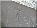
Benchmark on #18 Viewbank, Leslie
Ordnance Survey benchmark, described on database at https://www.bench-marks.org.uk/bm152820. See also Image
Image: © Becky Williamson
Taken: 10 Aug 2021
0.14 miles
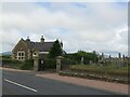
5
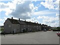
Viewbank, Leslie
There is an Ordnance Survey benchmark on the left-most house in the photo. See Image
Image: © Becky Williamson
Taken: 10 Aug 2021
0.14 miles
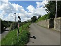
6
Benchmark on wall, Walkerton Drive, Leslie
Ordnance Survey benchmark, described on database at https://www.bench-marks.org.uk/bm152819. See also Image
Image: © Becky Williamson
Taken: 10 Aug 2021
0.15 miles
7
Walkerton Drive, Leslie
There is an Ordnance Survey benchmark on this wall. See Image
Image: © Becky Williamson
Taken: 10 Aug 2021
0.16 miles
8
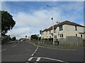
#3 Maryfield Crescent, Leslie
There is an Ordnance Survey benchmark on the house on the right. See Image
Image: © Becky Williamson
Taken: 10 Aug 2021
0.17 miles
9
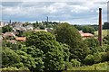
Leslie
A view of Leslie from the west, the chimney on the right is all that remains of a bleaching mill and the chimney in the distance is a paper mill.
Image: © Paul McIlroy
Taken: 29 Jun 2007
0.18 miles
10
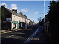
Leslie, Fife
View along the main street of this town which is separated from the New Town of Glenrothes by the river Leven. The church spire in the sistance marks the eastern edge of this grid square.
Image: © Kevin Rae
Taken: 24 Feb 2006
0.18 miles