IMAGES TAKEN NEAR TO
Whitehill Road, GLENROTHES, KY6 2RW
Introduction
This page details the photographs taken nearby to Whitehill Road, KY6 2RW by members of the Geograph project.
The Geograph project started in 2005 with the aim of publishing, organising and preserving representative images for every square kilometre of Great Britain, Ireland and the Isle of Man.

There are currently over 7.5m images from over14,400 individuals and you can help contribute to the project by visiting https://www.geograph.org.uk
Image Map
Images are licensed for reuse under creativecommons.org/licenses/by-sa/2.0
Notes
- Clicking on the map will re-center to the selected point.
- The higher the marker number, the further away the image location is from the centre of the postcode.
Image Listing (2 Images Found)
Images are licensed for reuse under creativecommons.org/licenses/by-sa/2.0
Image
Details
Distance
1
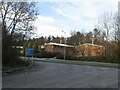
Whitehill Industrial Estate, Glenrothes
Image: © Becky Williamson
Taken: 28 Dec 2020
0.15 miles
2
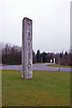
Road name monolith
It would be difficult to miss the name of this part of Glenrothes, which is largely given over to industrial units and office buildings. This sign stands at the junction between Golf Course Road and Viewfield.
Image: © Richard Dorrell
Taken: 6 Mar 2016
0.21 miles