IMAGES TAKEN NEAR TO
Rutherford Road, GLENROTHES, KY6 2RT
Introduction
This page details the photographs taken nearby to Rutherford Road, KY6 2RT by members of the Geograph project.
The Geograph project started in 2005 with the aim of publishing, organising and preserving representative images for every square kilometre of Great Britain, Ireland and the Isle of Man.

There are currently over 7.5m images from over14,400 individuals and you can help contribute to the project by visiting https://www.geograph.org.uk
Image Map
Images are licensed for reuse under creativecommons.org/licenses/by-sa/2.0
Notes
- Clicking on the map will re-center to the selected point.
- The higher the marker number, the further away the image location is from the centre of the postcode.
Image Listing (6 Images Found)
Images are licensed for reuse under creativecommons.org/licenses/by-sa/2.0
Image
Details
Distance
1

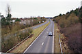
Faraday Road
A distribution road in a Glenrothes industrial estate.
Image: © Richard Webb
Taken: 9 Mar 2012
0.13 miles
2
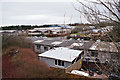
Industrial Estate, Southfield
A view over industrial units in Faraday Road from a footpath linking Southfield and Viewfield.
Image: © Richard Dorrell
Taken: 6 Mar 2016
0.17 miles
3
Airport access
The road towards Fife Airport crosses the B921 over this bridge
Image: © James Allan
Taken: 1 Mar 2006
0.19 miles
4
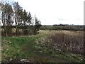
Unused land
Land on the edge of Glenrothes, currently out of use but as it is beside an industrial estate it is probably zoned for industry to (hopefully) come.
Image: © Richard Webb
Taken: 9 Mar 2012
0.19 miles
5
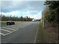
Kinglassie Road
Looking west from a footbridge between Viewfield and Faraday Road.
Image: © Richard Dorrell
Taken: 6 Mar 2016
0.21 miles
6
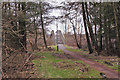
Footpath to Southfield
This short footpath starts from Viewfield, runs south over a footbridge crossing Kinglassie Road, and ends in Faraday Road.
Image: © Richard Dorrell
Taken: 6 Mar 2016
0.24 miles