IMAGES TAKEN NEAR TO
Muirfield Drive, GLENROTHES, KY6 2PX
Introduction
This page details the photographs taken nearby to Muirfield Drive, KY6 2PX by members of the Geograph project.
The Geograph project started in 2005 with the aim of publishing, organising and preserving representative images for every square kilometre of Great Britain, Ireland and the Isle of Man.

There are currently over 7.5m images from over14,400 individuals and you can help contribute to the project by visiting https://www.geograph.org.uk
Image Map
Images are licensed for reuse under creativecommons.org/licenses/by-sa/2.0
Notes
- Clicking on the map will re-center to the selected point.
- The higher the marker number, the further away the image location is from the centre of the postcode.
Image Listing (5 Images Found)
Images are licensed for reuse under creativecommons.org/licenses/by-sa/2.0
Image
Details
Distance
1
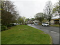
Barnton Place, Newcastle
Looking south-eastward.
Image: © Peter Wood
Taken: 8 May 2021
0.12 miles
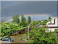
3
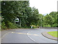
Bend in the road
At Cabbagehall Bridge across the River Leven between Leslie and Glenrothes.
Image: © James Allan
Taken: 1 Sep 2013
0.21 miles
4
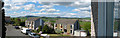
Panorama
Gleneagles Avenue Glenrothes with west Lomond Hill in the distance
Image: © David Johnston
Taken: 12 May 2002
0.24 miles
5
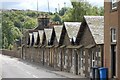
Cottages
These cottages on Greenwood Road used to accommodate mill workers and their families. Nowadays they are available to anyone who can afford them.
Image: © Paul McIlroy
Taken: 5 Jul 2007
0.25 miles