IMAGES TAKEN NEAR TO
Moffat Court, GLENROTHES, KY6 1JR
Introduction
This page details the photographs taken nearby to Moffat Court, KY6 1JR by members of the Geograph project.
The Geograph project started in 2005 with the aim of publishing, organising and preserving representative images for every square kilometre of Great Britain, Ireland and the Isle of Man.

There are currently over 7.5m images from over14,400 individuals and you can help contribute to the project by visiting https://www.geograph.org.uk
Image Map
Images are licensed for reuse under creativecommons.org/licenses/by-sa/2.0
Notes
- Clicking on the map will re-center to the selected point.
- The higher the marker number, the further away the image location is from the centre of the postcode.
Image Listing (12 Images Found)
Images are licensed for reuse under creativecommons.org/licenses/by-sa/2.0
Image
Details
Distance
1
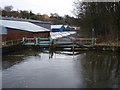
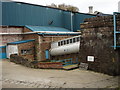
Fettykil Paper Mill Hydro-Electric Headworks
Sluice gates and overflow weir by which excess water by-passes the Hydro-Electric power station at Fettykil Paper Mill to return to the River Leven below. While Fettykil Paper Mill closed in June 2006, the hydro-electric station continues to generate supplying power for lighting the site.
Image: © David Bowie
Taken: 4 Feb 2008
0.22 miles
2
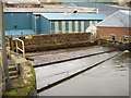
Fettykil Hydro-Electric Station Screens
The screens which protect the hydro-electric turbines by preventing the entry of tramp material. The hydro-electric station operates under a head of 33 feet, achieved by combining a series of smaller falls originally exploited by textile mills situated in close succession in the valley of the River Leven.
Image: © David Bowie
Taken: 4 Feb 2008
0.22 miles
3
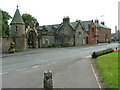
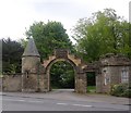
Arched entrance to Leslie House
Leslie House is the former ancestral home of the Earls of Rothes. It was badly damaged by fire in February 2009 while being converted into luxury flats.
Image: © Dave Fergusson
Taken: 1 Sep 2010
0.22 miles
4
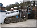
Fettykil Paper Mill Hydro-Electric Power Station
The penstock pipes of the small hydro-electric power station originally built by Smith Anderson Papermakers on the River Leven in the valley below the town of Leslie. The river itself runs below the roadway, emerging behind the stone wall to flow below the penstocks.
Image: © David Bowie
Taken: 4 Feb 2008
0.23 miles
5
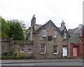
West Lodge, Leslie House
On the High Street, Old Town Leslie.
Image: © Stanley Howe
Taken: 17 May 2014
0.23 miles
6

Leslie House
The gates to Leslie House, now disused and in poor repair following a roof fire in 2009.
Image: © William Starkey
Taken: 26 Mar 2015
0.23 miles
7
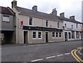
'The Clansman' pub
On Leslie 'old town' High Street, opposite the Town Hall (behind camera).
Image: © Stanley Howe
Taken: 17 May 2014
0.23 miles
8
Fettykil Hydro-Electric Generating Station
Another view of the small generating station at the former Smith Anderson Fettykil Paper Mill, Leslie. The weir seen in another view is below the penstock pipeline, immediately below the blue-painted handrails.
Image: © David Bowie
Taken: 4 Feb 2008
0.23 miles
9
Leslie House estate, West Lodge gate
Off Leslie old town High Street; opposite the War Memorial.
Image: © Stanley Howe
Taken: 17 May 2014
0.24 miles
10
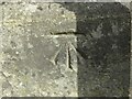
Benchmark on Leslie Town Hall
Ordnance Survey benchmark, described on database at https://www.bench-marks.org.uk/bm152765. See also Image
Image: © Becky Williamson
Taken: 10 Aug 2021
0.24 miles