IMAGES TAKEN NEAR TO
Kinglassie, LOCHGELLY, KY5 0UQ
Introduction
This page details the photographs taken nearby to KY5 0UQ by members of the Geograph project.
The Geograph project started in 2005 with the aim of publishing, organising and preserving representative images for every square kilometre of Great Britain, Ireland and the Isle of Man.

There are currently over 7.5m images from over14,400 individuals and you can help contribute to the project by visiting https://www.geograph.org.uk
Image Map
Images are licensed for reuse under creativecommons.org/licenses/by-sa/2.0
Notes
- Clicking on the map will re-center to the selected point.
- The higher the marker number, the further away the image location is from the centre of the postcode.
Image Listing (6 Images Found)
Images are licensed for reuse under creativecommons.org/licenses/by-sa/2.0
Image
Details
Distance
1
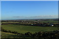
Finmont Farm Kinglassie
Viewed from the Whitehill looking down onto Finmont Farm.
Image: © edward mcmaihin
Taken: 4 Dec 2013
0.04 miles
2
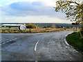
Approach to Fife Airport
The side road left leads to Fife Airport. The circular sign advertises the Airport restaurant, the 'Tipsy Nipper', named, not after an inebriated youngster, but after the first aeroplane owned by the flying club, a single-seat machine known as a Nipper, manufactured by the Belgian Tipsy aircraft company.
Image: © James Allan
Taken: 11 Nov 2006
0.09 miles
3
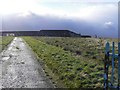
Reservoir wall
Concrete reservoir tanks on Whitehill which hold water supplies for Glenrothes.
Image: © James Allan
Taken: 11 Nov 2006
0.15 miles
4
Sign for Fife Airport
From the road to Auchmuirbridge.
Image: © Becky Williamson
Taken: 28 Dec 2020
0.24 miles
5

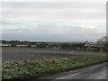
Closed road
While not in the same league as death and taxes, a closed road is almost inevitable if going out after grid squares in Scotland. This one is by the Fife Airport by Glenrothes.
Image: © Richard Webb
Taken: 9 Mar 2012
0.24 miles
6
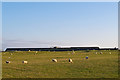
Grazing land near Finmont Farm
Sheep grazing near Finmont Farm, with Whitehill reservoir visible on the skyline.
Image: © William Starkey
Taken: 30 Jan 2012
0.25 miles