IMAGES TAKEN NEAR TO
Kinglassie, LOCHGELLY, KY5 0UG
Introduction
This page details the photographs taken nearby to KY5 0UG by members of the Geograph project.
The Geograph project started in 2005 with the aim of publishing, organising and preserving representative images for every square kilometre of Great Britain, Ireland and the Isle of Man.

There are currently over 7.5m images from over14,400 individuals and you can help contribute to the project by visiting https://www.geograph.org.uk
Image Map
Images are licensed for reuse under creativecommons.org/licenses/by-sa/2.0
Notes
- Clicking on the map will re-center to the selected point.
- The higher the marker number, the further away the image location is from the centre of the postcode.
Image Listing (4 Images Found)
Images are licensed for reuse under creativecommons.org/licenses/by-sa/2.0
Image
Details
Distance
1
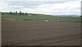
Arable land, Kinninmonth
A clear day with a view towards the Lammermuir Hills.
Image: © Richard Webb
Taken: 26 Apr 2013
0.09 miles
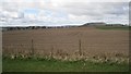
3
Farm Road
This photo was taken from the access road to Kinninmonth Farm, the view is to the north.
Image: © Paul McIlroy
Taken: 10 Oct 2007
0.15 miles
4
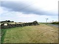
Kininmonth Farm road
North end of the road leading into Kininmonth Farm.
Image: © James Allan
Taken: 21 Aug 2006
0.24 miles