IMAGES TAKEN NEAR TO
Cardenden, LOCHGELLY, KY5 0HR
Introduction
This page details the photographs taken nearby to KY5 0HR by members of the Geograph project.
The Geograph project started in 2005 with the aim of publishing, organising and preserving representative images for every square kilometre of Great Britain, Ireland and the Isle of Man.

There are currently over 7.5m images from over14,400 individuals and you can help contribute to the project by visiting https://www.geograph.org.uk
Image Map
Images are licensed for reuse under creativecommons.org/licenses/by-sa/2.0
Notes
- Clicking on the map will re-center to the selected point.
- The higher the marker number, the further away the image location is from the centre of the postcode.
Image Listing (7 Images Found)
Images are licensed for reuse under creativecommons.org/licenses/by-sa/2.0
Image
Details
Distance
1
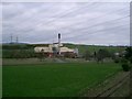
Westfield Biomass Plant
http://www.esru.strath.ac.uk/EandE/Web_sites/01-02/RE_info/biomasscase.htm
Image: © Paul McIlroy
Taken: 30 Apr 2006
0.01 miles
2
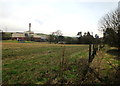
Arable Land at Capledrae
Arable land at Capledrae with Fife Environmental Energy Park in the background.
Image: © edward mcmaihin
Taken: 10 Jan 2012
0.14 miles
3

Capledrae Pylon
Pylon close to the Capledrae Substation.
Image: © edward mcmaihin
Taken: 10 Jan 2012
0.22 miles
4
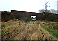
Road Bridge at Capledrae
B9097 road bridge at Capledrae viewed from the dismantled railway.
Image: © edward mcmaihin
Taken: 10 Jan 2012
0.23 miles
5

Energy, Old and New
In this picture is the Westfield Biomass energy plant, the Westfield Wind Farm and the water-filled remains of Westfield open-cast coal mine, at one time claimed to be the largest in Europe.
Image: © Robert Struthers
Taken: 6 Mar 2021
0.23 miles
6
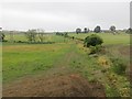
Kinross-shire Railway
A branch of the Kinross-shire Railway which ran between Redford and Kelty, servicing collieries. The road bridge is still there but the trackbed is hard to make out below.
Image: © Richard Webb
Taken: 22 Jul 2013
0.25 miles
7
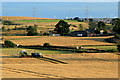
Harvest Time at Middleburn
Barley being harvested at Middleburn.
Image: © edward mcmaihin
Taken: 27 Aug 2013
0.25 miles