IMAGES TAKEN NEAR TO
Spence Avenue, BURNTISLAND, KY3 9JF
Introduction
This page details the photographs taken nearby to Spence Avenue, KY3 9JF by members of the Geograph project.
The Geograph project started in 2005 with the aim of publishing, organising and preserving representative images for every square kilometre of Great Britain, Ireland and the Isle of Man.

There are currently over 7.5m images from over14,400 individuals and you can help contribute to the project by visiting https://www.geograph.org.uk
Image Map
Images are licensed for reuse under creativecommons.org/licenses/by-sa/2.0
Notes
- Clicking on the map will re-center to the selected point.
- The higher the marker number, the further away the image location is from the centre of the postcode.
Image Listing (20 Images Found)
Images are licensed for reuse under creativecommons.org/licenses/by-sa/2.0
Image
Details
Distance
1
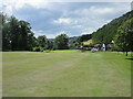
Burntisland Golf House Club, 18th Hole, Coronation '53
The final hole at Burntisland, looking down the hill to the green, with the clubhouse on the right.
Image: © Scott Cormie
Taken: 4 Aug 2022
0.11 miles
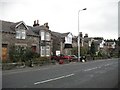
2
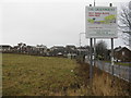
Building plots for sale
On Kirkcaldy Road, Burntisland [B923].
Image: © M J Richardson
Taken: 30 Mar 2018
0.14 miles
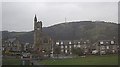
3
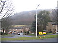
The Binn, in rain
Housing on the eastern edge of Burntisland.
Image: © M J Richardson
Taken: 30 Mar 2018
0.15 miles
4
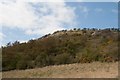
Widows Land, The Binn, Burntisland
Image: © Becky Williamson
Taken: 13 Apr 2019
0.17 miles
5
Kinghorn Road, Burntisland
Houses with a sea view (over the railway).
Image: © Richard Webb
Taken: 5 Sep 2009
0.18 miles
6
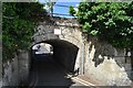
Lochies Road Bridge
More like a tunnel than a bridge, Lochies Road passes under the Fife Circle railway line at this point.
Image: © Robert Struthers
Taken: 4 Jun 2017
0.20 miles
7
Erskine Church, Burntisland
With The Binn radio transmitter on the hill to the rear. See http://www.burntisland.net/churches-article5.htm for the church's foundation a century ago.
Image: © Stanley Howe
Taken: 4 Apr 2009
0.20 miles
8
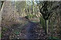
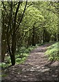
Pathway
This path is used by walkers, cyclists and horse riders as an alternative to the B923 Burntisland to Kinghorn road.
Image: © Paul McIlroy
Taken: 19 Jan 2008
0.20 miles
9
Footpath down The Binn
Approaching the B923.
Image: © Becky Williamson
Taken: 13 Apr 2019
0.20 miles
10
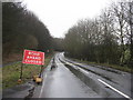
The B923 leaving Burntisland
Road closed - about 1250m ahead.
Image: © M J Richardson
Taken: 30 Mar 2018
0.21 miles