1
Kinghorn Road, Burntisland
Houses with a sea view (over the railway).
Image: © Richard Webb
Taken: 5 Sep 2009
0.13 miles
2
Burntisland Golf House Club, 18th Hole, Coronation '53
The final hole at Burntisland, looking down the hill to the green, with the clubhouse on the right.
Image: © Scott Cormie
Taken: 4 Aug 2022
0.14 miles
3
Lochies Road Bridge
More like a tunnel than a bridge, Lochies Road passes under the Fife Circle railway line at this point.
Image: © Robert Struthers
Taken: 4 Jun 2017
0.16 miles
4
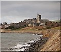
The foreshore at Burntisland
The foreshore at Burntisland, looking west to Erskine Free Church of Scotland.
Image: © Paul McIlroy
Taken: 4 Feb 2008
0.17 miles
5
Lochies Road
Lochies Road provides access to the small handful of properties on the seaward side of the Fife Circle railway line, through the low and narrow underpass in the middle distance.
Image: © Robert Struthers
Taken: 4 Jun 2017
0.18 miles
6
Fife coast near Burntisland
The rocky foreshore and sea wall on the Fife coast near Burntisland.
Image: © William Starkey
Taken: 17 Jan 2014
0.19 miles
7
Lochies Road
One of the escape routes from the beach past the railway.
Image: © Richard Webb
Taken: 5 Sep 2009
0.20 miles
8
The Old Pier, Burntisland
A not entirely satisfactory low-tide alternative to the not entirely satisfactory high-tide route of the Fife Coast Path which follows the A921. There is a narrow sandy strip sandwiched between the piles of rock backing up the concrete embankment to the right, and a large expanse of very wet sand to the left. Burntisland town beyond.
Image: © Oliver Dixon
Taken: 23 Mar 2022
0.20 miles
9
Burntisland Golf House Club, 17th Hole, The Bottle
The short seventeenth hole at Burntisland, looking from the tee over the rocks to the top of the flag on the hidden green in a hollow.
Image: © Scott Cormie
Taken: 4 Aug 2022
0.20 miles
10
Burntisland Sands
A not entirely satisfactory low-tide alternative to the not entirely satisfactory high-tide route of the Fife Coast Path which follows the A921. There is a narrow sandy strip sandwiched between the piles of rock backing up the railway embankment to the left, and a large expanse of very wet sand to the right.
Image: © Oliver Dixon
Taken: 23 Mar 2022
0.21 miles


