IMAGES TAKEN NEAR TO
Aberdour, BURNTISLAND, KY3 0SB
Introduction
This page details the photographs taken nearby to KY3 0SB by members of the Geograph project.
The Geograph project started in 2005 with the aim of publishing, organising and preserving representative images for every square kilometre of Great Britain, Ireland and the Isle of Man.

There are currently over 7.5m images from over14,400 individuals and you can help contribute to the project by visiting https://www.geograph.org.uk
Image Map
Images are licensed for reuse under creativecommons.org/licenses/by-sa/2.0
Notes
- Clicking on the map will re-center to the selected point.
- The higher the marker number, the further away the image location is from the centre of the postcode.
Image Listing (7 Images Found)
Images are licensed for reuse under creativecommons.org/licenses/by-sa/2.0
Image
Details
Distance
4
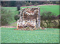
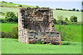
Ruined Dovecot
Looks like a giant's chair.
Image: © Simon Johnston
Taken: 28 Jan 2006
0.13 miles
5
The Doocot
This is another view from the adjacent road of the ruined Doocot (Dovecot).
Image: © Robin Clark
Taken: 11 Jul 2008
0.13 miles
6
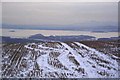
Inchcolm, Firth of Forth from Goat Quarry
Inchmickery and Cramond Islands can be seen left and right of pic. Pentland Hills, Edinburgh and Midlothian in the background.
Islands of the Forth: http://www.geograph.org.uk/gallery/islands_of_the_forth_6400
Image: © Simon Johnston
Taken: 3 Jan 2001
0.19 miles
7
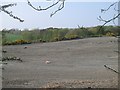
Gravel area, Goat Quarry
Plain of gravels opposite the entrance to Goat Quarry. A storage area before the stone was shipped out?
Image: © Richard Webb
Taken: 25 Apr 2009
0.23 miles