IMAGES TAKEN NEAR TO
Aberdour, BURNTISLAND, KY3 0RL
Introduction
This page details the photographs taken nearby to KY3 0RL by members of the Geograph project.
The Geograph project started in 2005 with the aim of publishing, organising and preserving representative images for every square kilometre of Great Britain, Ireland and the Isle of Man.

There are currently over 7.5m images from over14,400 individuals and you can help contribute to the project by visiting https://www.geograph.org.uk
Image Map
Images are licensed for reuse under creativecommons.org/licenses/by-sa/2.0
Notes
- Clicking on the map will re-center to the selected point.
- The higher the marker number, the further away the image location is from the centre of the postcode.
Image Listing (5 Images Found)
Images are licensed for reuse under creativecommons.org/licenses/by-sa/2.0
Image
Details
Distance
1

The Forth and Fife coast
From the Mound, Edinburgh, 1997.
Image: © Anthony O'Neil
Taken: 18 Aug 1997
0.14 miles
2

View from Torry Hill
Looking toward Burntisland and Docks.
A Royal Navy Destroyer on manoeuvres in the Firth of Forth.
Image: © Simon Johnston
Taken: 29 Apr 2007
0.21 miles
3
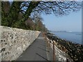
Fife Coastal Path beside Silversands Bay
The path which runs along the coast below the railway also doubles over this section at National Cycle Network route 76. Burntisland Docks can be seen on the horizon.
Image: © Oliver Dixon
Taken: 23 Mar 2022
0.23 miles
4
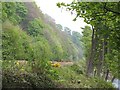
Edinburgh - Dundee railway
The railway running along the wooded shore of the Firth of Forth, between Aberdour and Burntisland.
Image: © Richard Webb
Taken: 25 Apr 2009
0.23 miles
5
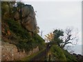
Old Nag Rock
'Hanging Craig'. A big lump of weathered rock threatens your peaceful stroll along the Fife Coastal Path.
Image: © Simon Johnston
Taken: 8 Nov 2008
0.24 miles