IMAGES TAKEN NEAR TO
BURNTISLAND, KY3 0LX
Introduction
This page details the photographs taken nearby to KY3 0LX by members of the Geograph project.
The Geograph project started in 2005 with the aim of publishing, organising and preserving representative images for every square kilometre of Great Britain, Ireland and the Isle of Man.

There are currently over 7.5m images from over14,400 individuals and you can help contribute to the project by visiting https://www.geograph.org.uk
Image Map
Images are licensed for reuse under creativecommons.org/licenses/by-sa/2.0
Notes
- Clicking on the map will re-center to the selected point.
- The higher the marker number, the further away the image location is from the centre of the postcode.
Image Listing (31 Images Found)
Images are licensed for reuse under creativecommons.org/licenses/by-sa/2.0
Image
Details
Distance
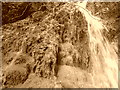
1

Waterfall on coastal path between Burntisland and Aberdour.
Image: © Josef Wilson
Taken: 7 Oct 2006
0.06 miles
2

The Forth and Fife coast
From the Mound, Edinburgh, 1997.
Image: © Anthony O'Neil
Taken: 18 Aug 1997
0.07 miles
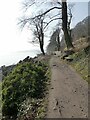
4
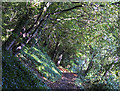
Fife coastal path
A section of the Fife coastal path passing through woodland near Burntisland.
Image: © William Starkey
Taken: 4 Oct 2013
0.09 miles
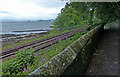
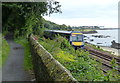
5
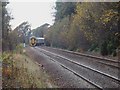
DMU to Edinburgh
Railway along the Fife Coast. Is it just me or do trains look rubbish when they mix stock? The train just passed had two of one and three of another all of different ages.
Image: © Simon Johnston
Taken: 8 Nov 2008
0.09 miles
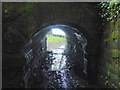
6
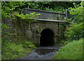
Fife Coastal Path passing under the railway
Image: © Mat Fascione
Taken: 22 Jul 2019
0.10 miles
7
Fife Coastal Path passing under the railway
Image: © Mat Fascione
Taken: 22 Jul 2019
0.10 miles
10
Fife Coastal Path beside Silversands Bay
The path which runs along the coast below the railway also doubles over this section at National Cycle Network route 76. Hawkcraig Point Image can be seen in the distance.
Image: © Oliver Dixon
Taken: 23 Mar 2022
0.11 miles