IMAGES TAKEN NEAR TO
Aberdour Road, BURNTISLAND, KY3 0EW
Introduction
This page details the photographs taken nearby to Aberdour Road, KY3 0EW by members of the Geograph project.
The Geograph project started in 2005 with the aim of publishing, organising and preserving representative images for every square kilometre of Great Britain, Ireland and the Isle of Man.

There are currently over 7.5m images from over14,400 individuals and you can help contribute to the project by visiting https://www.geograph.org.uk
Image Map
Images are licensed for reuse under creativecommons.org/licenses/by-sa/2.0
Notes
- Clicking on the map will re-center to the selected point.
- The higher the marker number, the further away the image location is from the centre of the postcode.
Image Listing (25 Images Found)
Images are licensed for reuse under creativecommons.org/licenses/by-sa/2.0
Image
Details
Distance
1
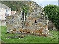
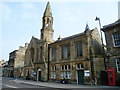
Kirkton Churchyard ruins
The ruins have a long history. http://www.burntisland.net/churches-article2.htm
Image: © kim traynor
Taken: 21 Oct 2011
0.06 miles
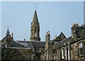
2
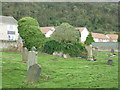
Kirkton Churchyard
The overgrown ruins of Burntisland's earliest church have an interesting history. http://www.burntisland.net/churches-article1.htm
Image: © kim traynor
Taken: 21 Oct 2011
0.06 miles
3
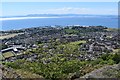
Burntisland from The Binn
The Binn is a volcanic plug that rises sharply to a height of 193 metres above the town of Burntisland.
Image: © Robert Struthers
Taken: 1 Jun 2020
0.09 miles
4
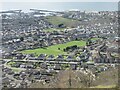
NEW
Playing fields in Burntisland from up high
Playing fields at Meadowfield in Burntisland, viewed from The Binn above the town.
Image: © Scott Cormie
Taken: 12 Mar 2025
0.15 miles
8
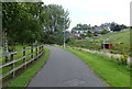
Cycleway and footpath in Kirkton, Burntisland
Image: © Mat Fascione
Taken: 22 Jul 2019
0.16 miles
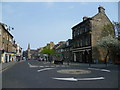
9
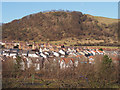
Kirkton
A housing estate on the west side of Burntisland, with the western end of The Binn beyond.
Image: © Rob Burke
Taken: 26 Feb 2013
0.16 miles
10
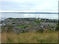
Burntisland from the Binn
Burntisland town and harbour viewed from Binn Hill just to its north. Beyond the Firth of Forth the far coast near Edinburgh can be seen.
Image: © James Allan
Taken: 5 Sep 2016
0.16 miles