IMAGES TAKEN NEAR TO
Glen Bruar Place, KIRKCALDY, KY2 6YY
Introduction
This page details the photographs taken nearby to Glen Bruar Place, KY2 6YY by members of the Geograph project.
The Geograph project started in 2005 with the aim of publishing, organising and preserving representative images for every square kilometre of Great Britain, Ireland and the Isle of Man.

There are currently over 7.5m images from over14,400 individuals and you can help contribute to the project by visiting https://www.geograph.org.uk
Image Map (Loading...)


Getting Data...Please wait
Leaflet Map data © OpenStreetMap
Images are licensed for reuse under creativecommons.org/licenses/by-sa/2.0
Notes
- Clicking on the map will re-center to the selected point.
- The higher the marker number, the further away the image location is from the centre of the postcode.
Image Listing (2 Images Found)
Images are licensed for reuse under creativecommons.org/licenses/by-sa/2.0
Image
Details
Distance
2
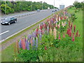
Kirkcaldy : Chapel : A910: Lupins flowering
The second season of the lupins flowering. These were planted as part of the road dualling. They provide a burst of colour during June. It will be interesting to see how long they flower and if they naturalise.
Image: © Kevin O'Kane
Taken: 14 Jun 2005
0.22 miles