IMAGES TAKEN NEAR TO
Dean Park Gardens, KIRKCALDY, KY2 6XX
Introduction
This page details the photographs taken nearby to Dean Park Gardens, KY2 6XX by members of the Geograph project.
The Geograph project started in 2005 with the aim of publishing, organising and preserving representative images for every square kilometre of Great Britain, Ireland and the Isle of Man.

There are currently over 7.5m images from over14,400 individuals and you can help contribute to the project by visiting https://www.geograph.org.uk
Image Map
Images are licensed for reuse under creativecommons.org/licenses/by-sa/2.0
Notes
- Clicking on the map will re-center to the selected point.
- The higher the marker number, the further away the image location is from the centre of the postcode.
Image Listing (8 Images Found)
Images are licensed for reuse under creativecommons.org/licenses/by-sa/2.0
Image
Details
Distance
1
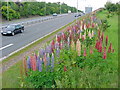
Kirkcaldy : Chapel : A910: Lupins flowering
The second season of the lupins flowering. These were planted as part of the road dualling. They provide a burst of colour during June. It will be interesting to see how long they flower and if they naturalise.
Image: © Kevin O'Kane
Taken: 14 Jun 2005
0.07 miles
3
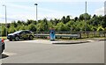
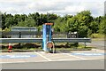
Electric vehicle charging point
In the car park of the Spiral Weave, Kirkcaldy. This one also offers an airline for inflating tyres.
The vehicle with 'St Andrews Shuttle' on its side is an airport taxi.
Image: © Bill Kasman
Taken: 27 Jul 2022
0.14 miles
4
Electric vehicle charging point
In the car park of the Spiral Weave, Kirkcaldy. This one also offers an airline for inflating tyres.
Image: © Bill Kasman
Taken: 27 Jul 2022
0.14 miles
5
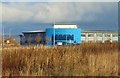
The Spiral Weave
A Marstons pub/restaurant this is a popular place for locals to eat and, being just off the A92 Fife Regional Road, it also attracts passing trade. This view is of the rear of the premises.
Image: © Bill Kasman
Taken: 30 Oct 2019
0.16 miles
6
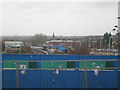
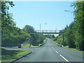
Bennochy Bridge, Kirkcaldy
This is Bennochy Bridge which acts as a viaduct with the railway line running straight under providing the route north of the town.
The main railway station building can be seen to the far left. A portion of the Whyte Melville Road car park is to the far right. Behind this is The Dundee University School of Midwivery and Nursing Kirkcaldy Campus and the spire of Abbotshall Church can be seen in the distance.
Image: © Ian Thomson
Taken: 10 Mar 2008
0.23 miles
7
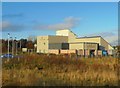
Lomond House
Situated in the John Smith Business Park, Kirkcaldy, this is now a call centre run by VeriCall. Previously it was a call centre run by MGT.
Image: © Bill Kasman
Taken: 30 Oct 2019
0.23 miles