IMAGES TAKEN NEAR TO
Barnton Road, KIRKCALDY, KY2 6XD
Introduction
This page details the photographs taken nearby to Barnton Road, KY2 6XD by members of the Geograph project.
The Geograph project started in 2005 with the aim of publishing, organising and preserving representative images for every square kilometre of Great Britain, Ireland and the Isle of Man.

There are currently over 7.5m images from over14,400 individuals and you can help contribute to the project by visiting https://www.geograph.org.uk
Image Map
Images are licensed for reuse under creativecommons.org/licenses/by-sa/2.0
Notes
- Clicking on the map will re-center to the selected point.
- The higher the marker number, the further away the image location is from the centre of the postcode.
Image Listing (4 Images Found)
Images are licensed for reuse under creativecommons.org/licenses/by-sa/2.0
Image
Details
Distance
1
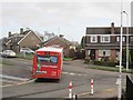
Dunnikier Estate
A K4 bus turns into Barassie Drive on what looks like a 1960s housing development on the northern edge of Kirkcaldy.
Image: © Richard Webb
Taken: 27 Jan 2013
0.20 miles
2
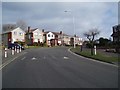
Late 1960's houses in Dunnikier Housing Estate
Image: © Douglas Nelson
Taken: 18 Feb 2019
0.20 miles
3
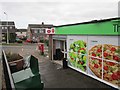
Dunnikier Post Office
Shop with a post office counter on the corner of Ralston Drive and Barassie Drive on the Dunnikier Estate.
Image: © Richard Webb
Taken: 27 Jan 2013
0.20 miles
4
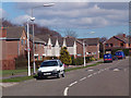
Duddingston Drive
Duddingston Drive on the Dunnikier estate. All the streets are named after golf courses.
Image: © John Darcy
Taken: 4 Apr 2006
0.20 miles