IMAGES TAKEN NEAR TO
Mellerstain Road, KIRKCALDY, KY2 6UD
Introduction
This page details the photographs taken nearby to Mellerstain Road, KY2 6UD by members of the Geograph project.
The Geograph project started in 2005 with the aim of publishing, organising and preserving representative images for every square kilometre of Great Britain, Ireland and the Isle of Man.

There are currently over 7.5m images from over14,400 individuals and you can help contribute to the project by visiting https://www.geograph.org.uk
Image Map
Images are licensed for reuse under creativecommons.org/licenses/by-sa/2.0
Notes
- Clicking on the map will re-center to the selected point.
- The higher the marker number, the further away the image location is from the centre of the postcode.
Image Listing (5 Images Found)
Images are licensed for reuse under creativecommons.org/licenses/by-sa/2.0
Image
Details
Distance
1
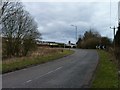
Torbain Road
At its junction with the A910 at Newliston.
Image: © James Allan
Taken: 2 Apr 2013
0.08 miles
2
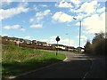
Looking back to the junction
With the A910 at Torbain Road in Kirkcaldy.
Image: © James Denham
Taken: 26 Apr 2010
0.09 miles
3
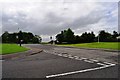
Forres Drive and Newliston Drive
The western edge of the Newliston and Chapel housing estates in Kirkcaldy.
Image: © Robert Struthers
Taken: 4 Jul 2015
0.19 miles
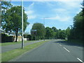
5
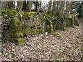
Buttressed wall
The boundary between Torbain Road and the Raith woodlands.
Image: © James Allan
Taken: 2 Apr 2013
0.25 miles