IMAGES TAKEN NEAR TO
Blackcraigs, KIRKCALDY, KY2 6TJ
Introduction
This page details the photographs taken nearby to Blackcraigs, KY2 6TJ by members of the Geograph project.
The Geograph project started in 2005 with the aim of publishing, organising and preserving representative images for every square kilometre of Great Britain, Ireland and the Isle of Man.

There are currently over 7.5m images from over14,400 individuals and you can help contribute to the project by visiting https://www.geograph.org.uk
Image Map
Images are licensed for reuse under creativecommons.org/licenses/by-sa/2.0
Notes
- Clicking on the map will re-center to the selected point.
- The higher the marker number, the further away the image location is from the centre of the postcode.
Image Listing (5 Images Found)
Images are licensed for reuse under creativecommons.org/licenses/by-sa/2.0
Image
Details
Distance
1
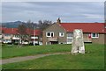
Chapel, Kirkcaldy
Once this was Bogie Mains farm, that's when the pillar would have been built. It survived the big housing expansion on the north west of Kirkcaldy and now sits on its hill top just by a bus stop.
Image: © Richard Webb
Taken: 8 Apr 2004
0.05 miles
2
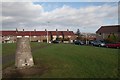
Bogie Mains Trigpoint, Kirkcaldy
Looking north. At 122 metres this is apparently the highest point in Kirkcaldy.
Image: © Becky Williamson
Taken: 16 Feb 2020
0.20 miles
3
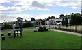
Fire damage to Torbain school, Kirkcaldy
Repair work in progress at Torbain nursery and infants school which was damaged by an act of wilful fireraising on the afternoon of Saturday, 12th August 2017. The fire caused extensive smoke damage to the building and the start of the new school term was delayed. Two local youths were arrested https://www.thecourier.co.uk/fp/news/local/fife/489671/youths-charged-in-connection-with-fire-at-fife-primary/
Image: © Bill Kasman
Taken: 19 Aug 2017
0.23 miles
4
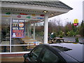
McDonald's Drive-Thru (window and golden arches sign), Kirkcaldy
The golden arches sign can be seen to the far right
Image: © Ian Thomson
Taken: 10 Mar 2008
0.23 miles
5
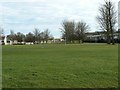
Green space in suburbia
A small open area of grass amid housing, seen from Broom Road.
Image: © James Allan
Taken: 17 Feb 2009
0.23 miles