IMAGES TAKEN NEAR TO
Glamis Road, KIRKCALDY, KY2 6LW
Introduction
This page details the photographs taken nearby to Glamis Road, KY2 6LW by members of the Geograph project.
The Geograph project started in 2005 with the aim of publishing, organising and preserving representative images for every square kilometre of Great Britain, Ireland and the Isle of Man.

There are currently over 7.5m images from over14,400 individuals and you can help contribute to the project by visiting https://www.geograph.org.uk
Image Map (Loading...)


Getting Data...Please wait
Leaflet Map data © OpenStreetMap
Images are licensed for reuse under creativecommons.org/licenses/by-sa/2.0
Notes
- Clicking on the map will re-center to the selected point.
- The higher the marker number, the further away the image location is from the centre of the postcode.
Image Listing (6 Images Found)
Images are licensed for reuse under creativecommons.org/licenses/by-sa/2.0
Image
Details
Distance
2
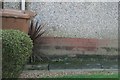
Benchmark, #43 Atholl Terrace, Kirkcaldy
Ordnance Survey benchmark, described on database at https://www.bench-marks.org.uk/bm116273. See also Image
Image: © Becky Williamson
Taken: 16 Feb 2020
0.14 miles
3
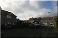
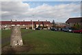
#43 Atholl Terrace, Kirkcaldy
There is an Ordnance Survey benchmark on the house on the left. See Image
Image: © Becky Williamson
Taken: 16 Feb 2020
0.15 miles
4
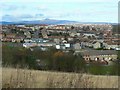
Templehall district
Templehall area of Kirkcaldy seen from Bennochy Road. The hill on the horizon is East Lomond.
Image: © James Allan
Taken: 17 Feb 2009
0.23 miles
5
Bogie Mains Trigpoint, Kirkcaldy
Looking north. At 122 metres this is apparently the highest point in Kirkcaldy.
Image: © Becky Williamson
Taken: 16 Feb 2020
0.23 miles
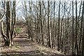
6
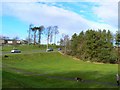
Dog walking in the park
A corner of Rabbit Park, with traffic on Broom Road visible in the background.
Image: © James Allan
Taken: 17 Feb 2009
0.23 miles