IMAGES TAKEN NEAR TO
Braids Road, KIRKCALDY, KY2 6JW
Introduction
This page details the photographs taken nearby to Braids Road, KY2 6JW by members of the Geograph project.
The Geograph project started in 2005 with the aim of publishing, organising and preserving representative images for every square kilometre of Great Britain, Ireland and the Isle of Man.

There are currently over 7.5m images from over14,400 individuals and you can help contribute to the project by visiting https://www.geograph.org.uk
Image Map (Loading...)


Getting Data...Please wait
Leaflet Map data © OpenStreetMap
Images are licensed for reuse under creativecommons.org/licenses/by-sa/2.0
Notes
- Clicking on the map will re-center to the selected point.
- The higher the marker number, the further away the image location is from the centre of the postcode.
Image Listing (4 Images Found)
Images are licensed for reuse under creativecommons.org/licenses/by-sa/2.0
Image
Details
Distance
1
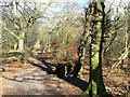
Twixt housing estate and golf course
A surprisingly rural woodland scene only, a few yards from Dunnikeir housing estate to the left and Dunnikier golf course to the right.
Image: © James Allan
Taken: 27 Feb 2008
0.11 miles
2
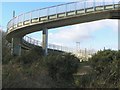
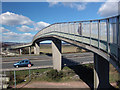
Sinuous bridge
An expensive structure of complex curves, this steel and concrete bridge carries nothing more than a footpath across the busy arterial A92 road.
Image: © James Allan
Taken: 27 Feb 2008
0.20 miles
4
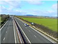
A92 looking west
Viewed from the sinuous footbridge spanning the express road.
Image: © James Allan
Taken: 27 Feb 2008
0.25 miles