IMAGES TAKEN NEAR TO
Chapel Level, KIRKCALDY, KY2 6HG
Introduction
This page details the photographs taken nearby to Chapel Level, KY2 6HG by members of the Geograph project.
The Geograph project started in 2005 with the aim of publishing, organising and preserving representative images for every square kilometre of Great Britain, Ireland and the Isle of Man.

There are currently over 7.5m images from over14,400 individuals and you can help contribute to the project by visiting https://www.geograph.org.uk
Image Map
Images are licensed for reuse under creativecommons.org/licenses/by-sa/2.0
Notes
- Clicking on the map will re-center to the selected point.
- The higher the marker number, the further away the image location is from the centre of the postcode.
Image Listing (6 Images Found)
Images are licensed for reuse under creativecommons.org/licenses/by-sa/2.0
Image
Details
Distance
1
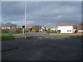
Barassie Drive entrance to Dunnikier Housing Estate
Image: © Douglas Nelson
Taken: 18 Feb 2019
0.05 miles
2
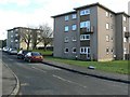
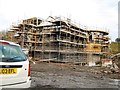
Four-storey flats
Blocks of flats in Tiree Place.
Image: © James Allan
Taken: 17 Feb 2009
0.06 miles
4
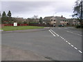
Dunnikier Estate entrance, Rosemount Avenue, Kirkcaldy
This is the entrance to Dunnikier Estate situated between Chapel Level and Dunnikier Way, two main Kirkcaldy roads.
The estate was built in several stages between 1971 and 1987. The estate was formerly the home of Dunnikier Colliery.
Image: © Ian Thomson
Taken: 12 Mar 2008
0.12 miles
6
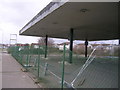
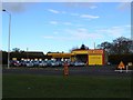
Former Esso petrol station, Chapel Level, Kirkcaldy
This is apparently the remains of the former Esso petrol station on Chapel Level that sadly closed in 2005. The obvious reason for the closure was the space was needed for housing. Now the nearest petrol station to the north of this picture is Sainsbury's which has become extremely busy as a result.
here today... gone tomorrow...
Image: © Ian Thomson
Taken: 12 Mar 2008
0.17 miles