IMAGES TAKEN NEAR TO
Valley Gardens, KIRKCALDY, KY2 6BN
Introduction
This page details the photographs taken nearby to Valley Gardens, KY2 6BN by members of the Geograph project.
The Geograph project started in 2005 with the aim of publishing, organising and preserving representative images for every square kilometre of Great Britain, Ireland and the Isle of Man.

There are currently over 7.5m images from over14,400 individuals and you can help contribute to the project by visiting https://www.geograph.org.uk
Image Map
Images are licensed for reuse under creativecommons.org/licenses/by-sa/2.0
Notes
- Clicking on the map will re-center to the selected point.
- The higher the marker number, the further away the image location is from the centre of the postcode.
Image Listing (7 Images Found)
Images are licensed for reuse under creativecommons.org/licenses/by-sa/2.0
Image
Details
Distance
1
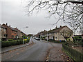
Cheviot Road
A residential area of Kirkcaldy.
Image: © Richard Webb
Taken: 9 Mar 2012
0.10 miles
2
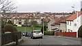
Cairnwell Place, Templehall
Residential road in urban Kirkcaldy.
Image: © Richard Dorrell
Taken: 23 Nov 2015
0.15 miles
3
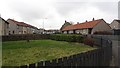
Benarty Street
Residential area, Kirkcaldy.
Image: © Richard Webb
Taken: 9 Mar 2012
0.20 miles
4
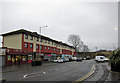
Shops and flats, Templehall
The road is Dunearn Drive.
Image: © Richard Dorrell
Taken: 23 Nov 2015
0.22 miles
5
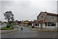
Pub and shops, Templehall
Looking across Dunearn Drive to Brodick Road.
Image: © Richard Dorrell
Taken: 23 Nov 2015
0.22 miles
6
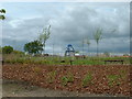
Kirkcaldy : Templehall Millennium Park
A new community park created by the efforts of the local community. On the site of Kirkcaldy High School part of the site was sold off for housing. The park includes a wildlife garden, a fruit garden (the trees in the picture are apple) and a play area with climbing structure.
Image: © Kevin O'Kane
Taken: 21 May 2002
0.23 miles
7
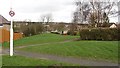
Path off Benarty Street
A strip of land which was not built upon during the expansion of Kirkcaldy.
Image: © Richard Webb
Taken: 9 Mar 2012
0.25 miles