IMAGES TAKEN NEAR TO
Valley Gardens South, KIRKCALDY, KY2 6AW
Introduction
This page details the photographs taken nearby to Valley Gardens South, KY2 6AW by members of the Geograph project.
The Geograph project started in 2005 with the aim of publishing, organising and preserving representative images for every square kilometre of Great Britain, Ireland and the Isle of Man.

There are currently over 7.5m images from over14,400 individuals and you can help contribute to the project by visiting https://www.geograph.org.uk
Image Map (Loading...)


Getting Data...Please wait
Leaflet Map data © OpenStreetMap
Images are licensed for reuse under creativecommons.org/licenses/by-sa/2.0
Notes
- Clicking on the map will re-center to the selected point.
- The higher the marker number, the further away the image location is from the centre of the postcode.
Image Listing (6 Images Found)
Images are licensed for reuse under creativecommons.org/licenses/by-sa/2.0
Image
Details
Distance
1
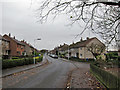
Cairnwell Place, Templehall
Residential road in urban Kirkcaldy.
Image: © Richard Dorrell
Taken: 23 Nov 2015
0.17 miles
2
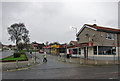
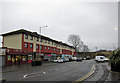
Pub and shops, Templehall
Looking across Dunearn Drive to Brodick Road.
Image: © Richard Dorrell
Taken: 23 Nov 2015
0.20 miles
3
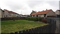
Cheviot Road
A residential area of Kirkcaldy.
Image: © Richard Webb
Taken: 9 Mar 2012
0.22 miles
4
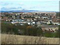
Templehall district
Templehall area of Kirkcaldy seen from Bennochy Road. The hill on the horizon is East Lomond.
Image: © James Allan
Taken: 17 Feb 2009
0.22 miles
5
Shops and flats, Templehall
The road is Dunearn Drive.
Image: © Richard Dorrell
Taken: 23 Nov 2015
0.22 miles
6
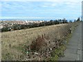
Pavement with a panorama
The pavement along Bennochy Road affords a fine view across Kirkcaldy to the Firth of Forth.
Image: © James Allan
Taken: 17 Feb 2009
0.24 miles