IMAGES TAKEN NEAR TO
Cluny, KIRKCALDY, KY2 6AR
Introduction
This page details the photographs taken nearby to KY2 6AR by members of the Geograph project.
The Geograph project started in 2005 with the aim of publishing, organising and preserving representative images for every square kilometre of Great Britain, Ireland and the Isle of Man.

There are currently over 7.5m images from over14,400 individuals and you can help contribute to the project by visiting https://www.geograph.org.uk
Image Map
Images are licensed for reuse under creativecommons.org/licenses/by-sa/2.0
Notes
- Clicking on the map will re-center to the selected point.
- The higher the marker number, the further away the image location is from the centre of the postcode.
Image Listing (4 Images Found)
Images are licensed for reuse under creativecommons.org/licenses/by-sa/2.0
Image
Details
Distance
1
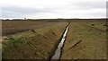
Reclaimed opencast
A ditch on the site of a huge opencast coal mine. Strathore had several pits and later saw a lot of opencast mining. There is talk of building 40 bonded warehouses around here.
Image: © Richard Webb
Taken: 9 Mar 2012
0.11 miles
2
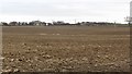
Reclaimed open cast site
Farmland between the Ore and A92 with a distant view of the bridge on Johnny Marshall's Loan.
Image: © Richard Webb
Taken: 9 Mar 2012
0.13 miles
3
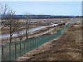
Converting reclaimed open cast site
Just north of The Begg Farm, workers of the ISG construction group are preparing the access and foundations for a new bonded warehouse for the Diageo whisky company. Only recently returned to agricultural use following years as an open-cast coal mine, this land is about to see yet another change of use.
Image: © James Allan
Taken: 2 Apr 2013
0.17 miles
4
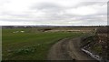
Reclaimed open cast site
Now back in production as arable farmland. I was told locally that there are plans to put bonded warehouses in the area.
Image: © Richard Webb
Taken: 9 Mar 2012
0.21 miles